
 Yahoo News
 Weather map shows when UK will experience another heatwave in July
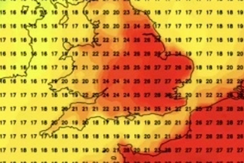
Weather maps show an intense red for most of the UK as a new heatwave is forecast for July. A subtropical Mediterranean airstream is likely to spark another hot spell, sending temperatures to a scorching 30C again, mirroring the warm smells from earlier this week.
The Mirror reports that the latest heatwave will enjoy its peak on Sunday, July 14, according to Netweather. It will be around 30C across Greater London and neighboring countries, with the mercury surpassing 25C in Southwest England, early indications suggest.
However, since the sizzling temperates on Wednesday (June 26), it has been rather unsettled with heavy rainfall. Further showers are forecasted for today, particularly across parts of the Midlands.
Read more: Coventry dad put symptoms down to 'tiredness and COVID' as tell-tale cancer sign was missed
Despite the weather maps, the Met Office's long-range forecasts see weather alternate quickly between wet and dry conditions. In the forecasts for the middle to the end of July, the Met Office predicts: "On balance most likely rather changeable at first, with periods of unsettled and cloudy, wet weather mixed with spells of dry and fine weather, with weather systems tending to come from the west.
"This means that the west is likely to see the wettest conditions, while the east will tend to be drier. By mid-month, there is a signal for more settled conditions to develop, so more in the way of dry weather, although still with a risk of some rain/showers at times. Temperatures close to average at first, but with a greater chance of warmer than average conditions later in the period."
Temperatures at the end of this week have struggled to reach anywhere near Tuesday and Wednesday's 30C highs. On Friday, they peaked at 22C at Heathrow Airport in west London, nearly 10C colder than the baking 31C peak experienced in nearby Surrey on Wednesday.
For Coventry, today will be a largely dry day with bright or sunny spells, with a chance of a few well-scattered light showers during the afternoon, with a maximum temperature of 19C. Tonight will be feeling cool, with light winds, with a minimum temperature of 8C.
Here is the Met Office outlook for Coventry over the next few days:
Monday:
A dry and bright start, before a band of clouds and outbreaks of rain, locally heavy, moves eastwards across all parts during the day. Temperatures are near average. Light winds. Maximum temperature 20 °C.
Outlook for Tuesday to Thursday:
Largely dry with bright or sunny spells Tuesday, perhaps a few scattered showers. Dry at first on Wednesday, before rain arrives later. Breezy with sunny spells and scattered showers on Thursday.
Get daily headlines and breaking news emailed to you - it’s FREE

