
 Yahoo News
 Weather maps predict -1C temperature plummet
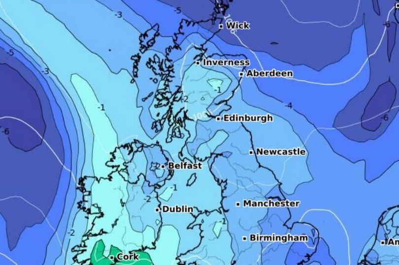
The latest weather maps show temperatures could plummet to a chilly -1C this week. Parts of northern England and southern Scotland have provisionally recorded the wettest April on record and it seems more showers are also on the way.
Highs of 16C were expected today (Monday, April 22), dropping to 9C throughout the week. GB News reports that by mid-week, it'll be cold and wet as low pressure moves in off the Atlantic.
The cold blast is expected to hit from 6am on Thursday, April 25, and a fall in pressure looks set to bring showers. According to forecasters, more wet weather is also looking likely for Friday, April 26.
READ MORE: EastEnders fans hope cast reunion at 'secret soiree' spells return of soap icon
Nick Finnis, a Net Weather forecaster, told the publication: "We saw some warmth earlier in the month, thanks to warm air moving up from Africa, culminating in 21.8C being reached on 13th at Writtle near Chelmsford, Essex – the warmest day of the year so far. However, it’s turned colder during the second half of this month, with northerly or northwesterly winds bringing cool days and some chilly nights."
However Met Office forecasters say tomorrow (Tuesday, April 23), will be "largely dry with increasing sunny spells". The remainder of the week will be more of the same, with weather watchers saying it would be "pleasant in the sunshine" but "chilly around coastal areas at times with brisk winds".

