
 Yahoo News
 Weather maps reveal when four-day 'mini-heatwave' to bring balmy 19C highs to UK

A four-day spell of hot weather is set to bring balmy highs of 19C to the UK next week. Brits will soon enjoy warmer weather, with the mercury anticipated to rise across many parts of the country.
Weather maps from WX Charts indicate it will start to heat up as we approach the early May bank holiday. It comes after heavy downpours and harsh winds have been sweeping Britain lately.
There will be highs of 17C on Thursday, May 2. The Midlands is predicted to see between 15C and 16C, while the south of the country could feel the warmest of the weather.
READ MORE: Boy, 16, 'brutally slain with Rambo blade in Wolverhampton crack den' - murder trial told
Sign up to the BirminghamLive newsletter here to get the latest updates on the biggest and breaking stories.
The heat will then continue into Friday, May 3. Balmy highs of 19C are expected in Wales, with temperatures between 16C and 17C along the south coast of England.
Highs of 17C are predicted for the Midlands, while it will be slightly chillier in the east of England at 14C. According to weather maps, the warmer conditions will remain on Saturday, May 4 and Sunday, May 5.
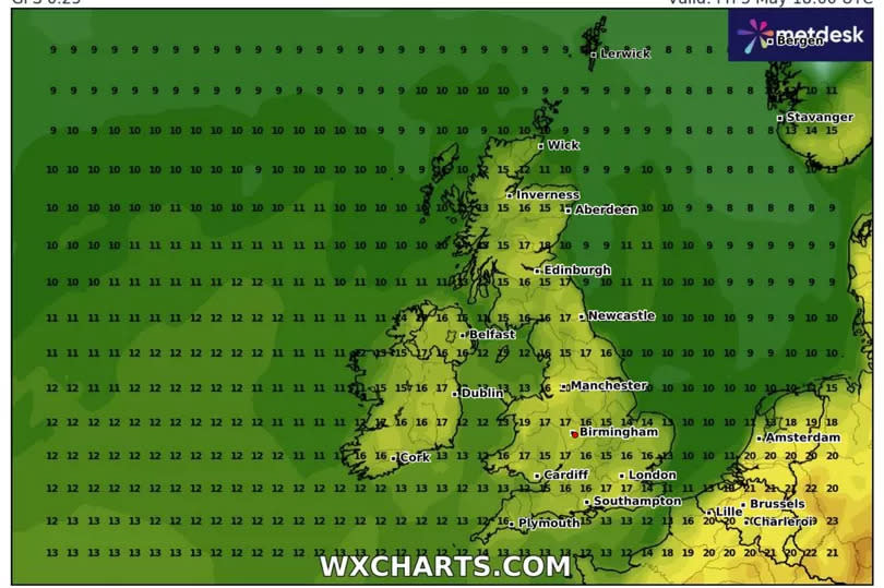
On Saturday, much of England will see highs of 17C and 18C. Similar temperatures are predicted for the north of England.
Temperatures in Scotland will be mixed but a warm 16C is anticipated in Edinburgh and 15C in Aberdeen. The weather will start to dip as we approach Sunday - but highs of 18C are still expected in some parts of England.
In its long-range forecast for Saturday, April 27, to Monday, May 6, the Met Office said: "An uncertain start to the period though likely unsettled as a frontal system pushes into southern areas and possibly across the UK through the weekend. Beyond this low pressure patterns becoming more dominant than of late with wet weather perhaps more likely to develop in parts of the south and east, with western and especially northern areas hanging on to the best of any drier interludes, though all parts are may see some rain at times.
"Onshore winds along eastern coasts will likely make it feel rather cold at times, though for all parts temperatures will likely trend back toward average. Into early May, something of a north-south split looks possible, with relatively drier conditions further to the north and the greatest chance of rain further to the south."

