
 Yahoo News
 Wet weekend in South to bring flood, severe weather threats


After a quiet start to the week across the South, a looming pattern change will bring a multiday risk of heavy rain and flooding that will extend into next week.
In classic El Niño fashion, an unrelentingly wet pattern across the South has put a major dent in drought conditions across the region this winter. Over the past three months, the coverage of drought conditions has been cut nearly in half, going from 80.7% in early November down to 42.8% in early February, according to the US Drought Monitor.
Further improvements in the drought are expected as a train of storms marches through the South, but it will also come with the risk of localized flooding and potent thunderstorms.
 |
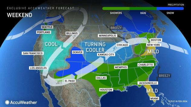
Warm and humid air flowing out of the Gulf of Mexico will promote showers from Texas through the southern United States on Friday, the start of the multiday stretch of wet weather for the region.
A continuation of rain is expected across many of the same areas of the South heading into Saturday, dampening outdoor plans and likely leading to travel delays.
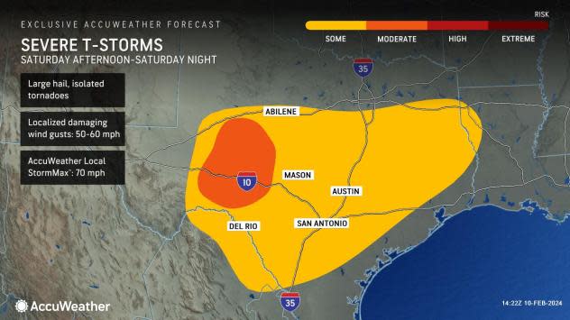
Ingredients for severe thunderstorms could materialize by Saturday night across portions of central Texas as well. Folks in and around Austin and San Antonio will face at least some risk of damaging wind gusts and a possible isolated tornado on Saturday night.
 |
Heavy rain and thunderstorms will continue to roll right into Sunday across the South. In addition to an increasing concern for flooding due to multiple days of rain, there could be another zone worth watching for severe thunderstorms across eastern Texas, Louisiana and Mississippi.
As these thunderstorms track east along the Gulf Coast, they could bring the potential for localized damaging wind gusts, hail and isolated tornadoes once again.
 |
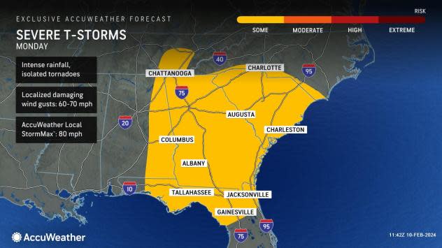
The risk of severe thunderstorms will continue to press eastward across the Southern states on Monday. Areas from northern Florida to South Carolina are most likely to have storms packing wind gusts of 60-70 mph and locally higher. Intense downpours can trigger flash urban flooding.
There is a chance that severe weather extends farther to the north, toward the southern Appalachians or a separate pocket of severe weather develops in the eastern parts of Tennessee and Kentucky.
 |
Conditions will slowly dry out across Texas and Louisiana before the start of the new week, but the slow-moving storm will continue to produce a steady rain across much of the Southeast on Monday. Places like Charlotte, North Carolina, and Atlanta may have travel-disrupting rain during Monday commute.
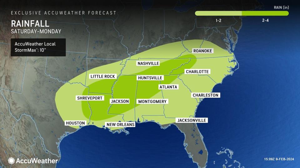
Tallying up the multiday stretch of wet weather, many areas across the South can receive more than an inch of rain between Friday and next Monday. A zone within these regions extending from eastern Texas into Louisiana, southern Arkansas, Mississippi, northern Alabama, southern and eastern Tennessee and into the southern Appalachians can pick up 2-4 inches of rain.
 |
Where the most persistent downpours occur, the AccuWeather Local StormMax™ of 10 inches of rainfall could be realized.
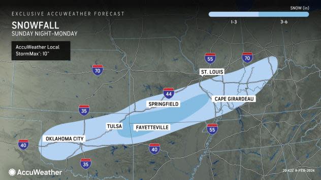
Chilly air surging in on the back side of the storm is also expected to produce a narrow corridor of accumulating snow heading into the new week. This snow will fall north and west of the heaviest rain, including parts of northern Texas, Oklahoma, northern Arkansas, Missouri and into Illinois.
 |
Tricky travel conditions are possible along the Interstate 44 corridor stretching from just east of Tulsa, Oklahoma, through just north of Cape Girardeau, Missouri, on Monday as the storm is expected to produce a swath of 3-6 inches of snow in the area. It is possible within this zone, some areas could get snowfall totals that approach the AccuWeather Local StormMax™ of 10 inches.
By Tuesday, the storm is expected to pick up speed and bring dry conditions back to the South, which could remain in place until late in the week.
Want next-level safety, ad-free? Unlock advanced, hyperlocal severe weather alerts when you subscribe to Premium+ on the AccuWeather app. AccuWeather Alerts™ are prompted by our expert meteorologists who monitor and analyze dangerous weather risks 24/7 to keep you and your family safer.
