
 Yahoo News
 Bristol still at risk of flooding as Portishead told to 'take action'
Parts of Bristol remain at risk of flooding due to gale force winds and spring tides. Water levels remain high along the South West coastline and the Environment Agency has issued another red flood warning, urging local residents to take action before another high tide.
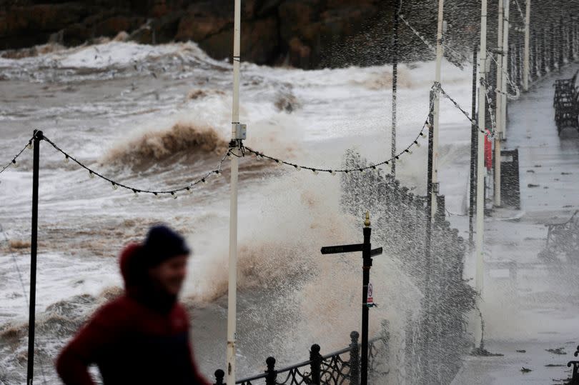
Huge winds buffeted the region overnight and the weather front - named Storm Pierrick by Meteofrance - caused chaos. Parts of the West Country was hit with torrential rain and winds of up to 70mph, causing giant waves to breach sea defences and flood the surrounding area.
A number of flood alerts are still active across North Somerset and Bristol, and residents in Portishead have been warned flooding is 'expected' in the area. The EA says: "Strong winds and spring tides may cause large waves and spray overtopping on the coast. Areas most at risk include the coastline between Portishead Point and Avonmouth including Portishead Ashlands Nature Reserve and the Royal Portbury Dock."
Read more:
Bristol is still facing very strong winds until later this evening (April 9) and more heavy rain is expected until tomorrow, according to the Met Office. Unlike previous months, however, the rain isn't expected to cause flooding - very high spring tides are.
The Environment Agency says that high tide at Portishead earlier today was expected to hit 7.81 mAODN (mAODN is the height above the average sea level). During high tide at 9.15am tomorrow (April 10) it is expected to reach a level of 7.97 mAODN. For details on flood warnings and alerts in Bristol, scroll below.
Flood warnings
Somerset coast at Portishead and Portbury Dock, seafront properties and Portbury Dock areas
Strong winds and spring tides may cause large waves and spray overtopping on the coast. Areas most at risk include the coastline between Portishead Point and Avonmouth including Portishead Ashlands Nature Reserve and the Royal Portbury Dock.
Our incident response staff are closing flood gates and checking defences. We continue to monitor levels closely. Please be careful along beaches, promenades, coastal footpaths and roads as large waves and sea spray could be dangerous.
Flood alerts
Somerset coast at Clevedon
Strong winds and spring tides may cause large waves and spray overtopping on the coast. Areas most at risk include the coastline between Gullhouse Point and Marine Parade.
The detailed tidal information for those who use it is for a peak level at Avonmouth. The first forecast high water is at 08:45 PM on Tuesday 09/04/2024 with a level of 7.81 mAODN with westerly force 5 winds. The second forecast high water is at 09:15 AM on Wednesday 10/04/2024 with a level of 7.97 mAODN with southerly force 4 winds. (mAODN is height above average sea level - for more info refer to local tide tables.)
Our incident response staff are closing flood gates and checking defences. We continue to monitor levels closely. Please be careful along beaches, promenades, coastal footpaths and roads as large waves and sea spray could be dangerous.
Somerset coast at Portishead and Portbury Dock
Strong winds and spring tides may cause large waves and spray overtopping on the coast. Areas most at risk include the coastline between Portishead Point and Avonmouth.
The detailed tidal information for those who use it is for a peak level at Avonmouth. The first forecast high water is at 08:45 PM on Tuesday 09/04/2024 with a level of 7.81 mAODN with westerly force 5 winds. The second forecast high water is at 09:15 AM on Wednesday 10/04/2024 with a level of 7.97 mAODN with southerly force 4 winds. (mAODN is height above average sea level - for more info refer to local tide tables.)
Our incident response staff are closing flood gates and checking defences. We continue to monitor levels closely. Please be careful along beaches, promenades, coastal footpaths and roads as large waves and sea spray could be dangerous.
Tidal River Avon at Bristol, Pill and Shirehampton
This Flood Alert has been updated due to the high tide forecast at tonight 08:45 PM on 09/04/2024 and 09:15 AM tomorrow morning 10/04/2024.
Areas most at risk include the tidal River Avon from Sea Mills to Conham in Bristol and between the Avonmouth Bridge and Shirehampton Park including Pill and Shirehampton.
First forecast high tide is this evening 09/04/2024 at 7.82 mAODN at which is 0.26 m above tide tables, with westerly force 5 winds. Second forecast high tide is 7.93mAOD tomorrow morning 10/04/2024 at which is 0.16m above tide tables, with force 5 southerly winds.
(mAODN is height above average sea level - for more info refer to local tide tables.) We are expecting higher than normal astronomical tides over the next 2 days due to spring tides.
We will be closing locks and flood gates in the area and we will continue to monitor levels closely. Please be careful along beaches, promenades, coastal footpaths.
Severn Estuary at Oldbury-on-Severn, Northwick and Avonmouth
As a result of high spring tides and strong winds, tides will be high tomorrow morning at 9:15 AM on 10/04/2024 at a level of 7.93mAOD. This evenings tide does not meet flood alert thresholds.
This Flood Alert has been issued because some minor flooding to coastal roads and footpaths is likely tomorrow morning and areas most at risk include the Severn Estuary at Oldbury-on-Severn, Northwick and Avonmouth including Aust and Old Passage.
The detailed tidal information for those who use it is for a peak level at Avonmouth of 7.93mAOD which is 0.16m above tide tables, with southerly force 5 winds. (mAODN is height above average sea level - for more info refer to local tide tables.)
Our incident response staff are closing flood gates and checking defences.
Please be careful along beaches, promenades, coastal footpaths and roads as large waves and sea spray could be dangerous.
After this tide‚ the weather is more settled and no further impacts are expected.

