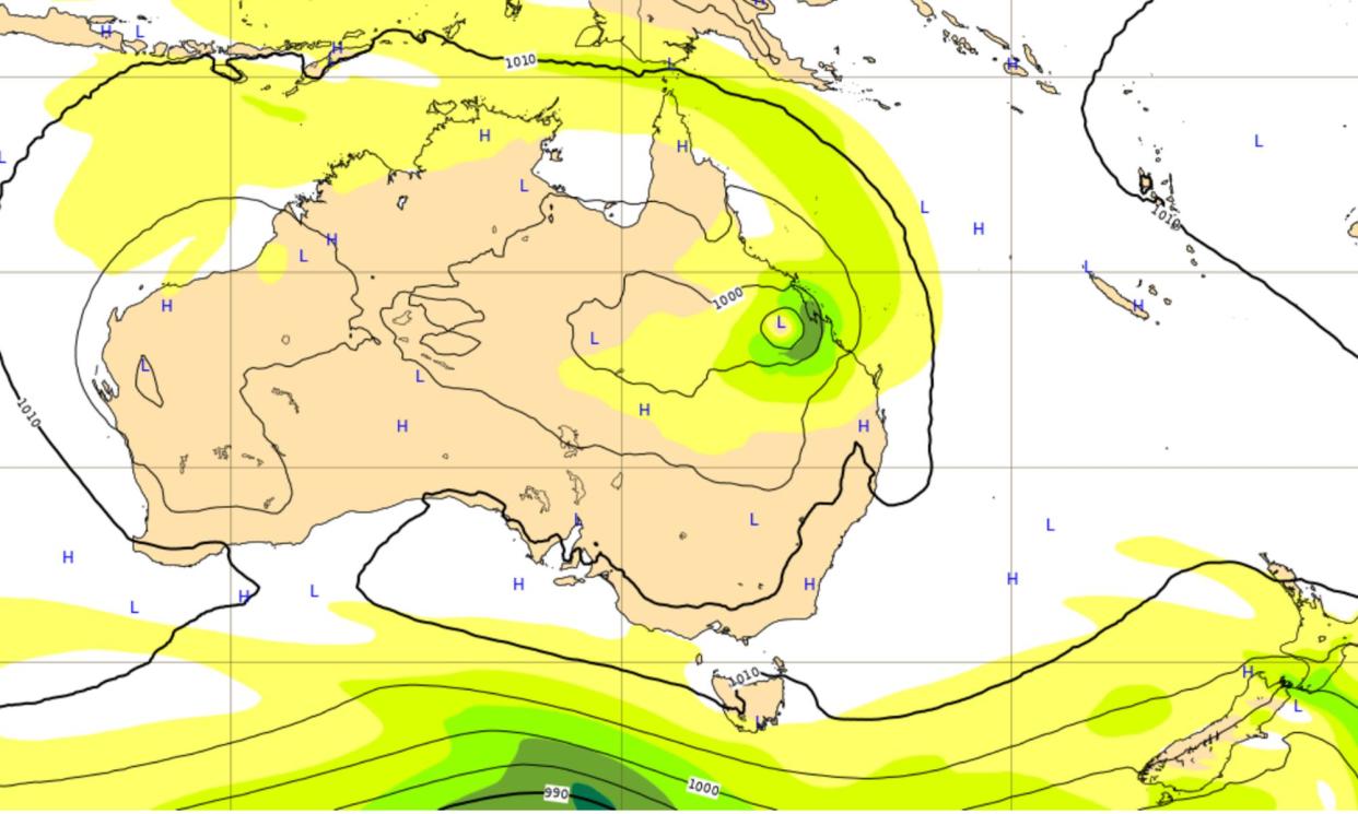
Cyclone forecasting boosted by artificial intelligence offers earlier path tracking

Cyclone forecasting is getting a boost from artificial intelligence models that can predict the risks of these extreme weather events with increasing accuracy.
Queenslanders told to be on alert by the Bureau of Meteorology for a second tropical cyclone to hit the state in just over a month now have extra ways to monitor the risks via online trackers predicting the potential path of the cyclone.
As of Wednesday afternoon, the bureau was rating the possibility that a low pressure system in the Coral Sea would form into a cyclone as a 60% chance by next Tuesday. Should it form, the cyclone would be named Kirrily.
Some models had the system turning towards the Queensland coast, said Daniel Hayes, a Cairns-based community information officer for the bureau.
“If it moves back towards the coast, probably somewhere between Cairns and Rockhampton is the more likely area for it to head towards,” Hayes said, adding, “it’s not expected to have any direct impact on the coast within the next seven days”.
It is too early for the bureau to issue a forecast track for the tempest. There is, though, “a chance that it could actually intensify to become a severe tropical cyclone, which is category three or stronger”, he said. Category 3 storms have mean wind speeds of 118km/h to 159km/h.
Other weather agencies, such as the well-regarded European Centre for Medium-Range Weather Forecasts (ECMWF) has a clear cyclone forming by next Friday.
However, forecasting generated by machine learning is increasingly available to the public, including via the European centre itself. Its Artificial Intelligence/Integrated Forecasting System (AIFS) model, for instance, has cyclone Kirrily nearing the Queensland coast much closer to Rockhampton than Cairns by late next Thursday.
The ECMWF launched its experimental model last October and also carries several other versions on its website produced using AI technology, such as by Google’s GraphCast and China’s Huawei Pangu model.
The centre said the more traditional physics-based numerical weather prediction models, such as its Integrated Forecasting System, remain “still key” to its predictions. One reason is the numerical models provide the initial conditions and the training datasets that the machine-learning versions work from.
Also, the AI models are based on single calculations, not the multiple calculations that produce the ensemble of results that the ECMWF would rely on to produce probability maps for cyclones.
Guardian Australia approached the bureau for comment. The bureau’s own Access model shows the system remaining well off the coast by Tuesday.
Jyoteeshkumar Reddy Papari, a postdoctoral researcher at the Csiro, said it remained “hard to more precisely predict the tropical cyclone (TC) track a week out even with the AI models”.
“Overall, the AI model is doing a reasonably good job in spinning the [tropical cyclone] and providing the possible track as good as the dynamical model,” Papari said.
Coral Sea tropical low 90P this AM now at max wind 20 kts with faring convection in the northern quadrants. Latest GEFS ensemble shows high uncertainty from its members beyond 72 hrs but a growing trend of a SE turn along the Subtropical ridge. The BoM's next TC name is Kirrily. pic.twitter.com/OHawctNbyz
— Hauraki Gulf Weather (@HaurakiGulfWx) January 17, 2024
Still, “people should be cautious about the possibility of [tropical cyclone] landfall [and] should take the official warnings” from official agencies such as the bureau.
Nevertheless, “they are useful guides to what’s coming”, he said. “We can expect more AI weather models even with ensemble-style forecasts and [they will] become more accessible to the public.”
Other models are throwing up a variety of tracks for the cyclone, such as the US’s Global Ensemble Forecast System.
Scientists working for Google’s DeepMind division last year published a peer-reviewed paper in the journal Science stating their GraphCast machine learning-based model had outperformed the most accurate operational systems on 90% of 1,380 targets.
Its forecasts also supported “better severe event prediction including tropical cyclone tracking, atmospheric rivers and extreme temperates”, the researchers said.

 Yahoo News
