
 Yahoo News
 Exact day Scotland could see 21C temperatures again in return of summery weather

Forecasters have predicted the exact day that 21C weather will return to Scotland this month as the nation will see some scorching temperatures once again.
The UK was recently bathed in some warm weather as Scotland saw highs of 24C across the weekend of May 11 and May 12 - and this will return in the coming days.
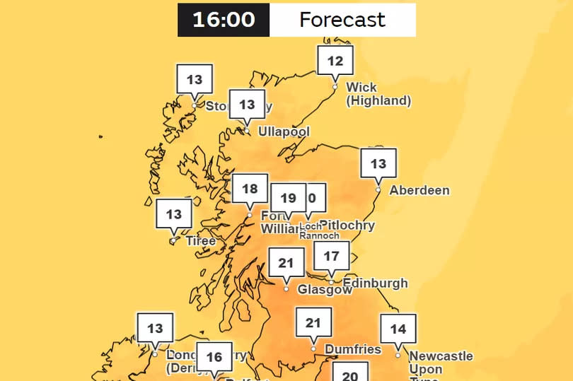
The Met Office's interactive weather map has shown that the central belt of Scotland and its southern border will welcome highs of 21C by Saturday, May 18 at 4pm. The warm weather will build across the nation throughout this weekend with Glasgow seeing a maximum of 21C and Edinburgh only reaching 17C by late afternoon.
Temperatures will continue to remain toasty through until Sunday May 19 with highs of 19C across Scotland and sunny skies across most of the nation.
WXCharts' latest weather maps also confirm that temperatures will improve this weekend with winds reaching a maximum of 3.3mph - meaning the country will feel the full effects of the warm weather.
The long-range forecast from the Met Office has also suggested that typically sunny conditions will "dominate" the UK from May 20 until May 29 - with a risk of some rain at times.
The latest long-range forecast on the Met Office website reads: "The week should start on a reasonable note in many areas, with a fair amount of dry and bright weather, especially in southern parts of the UK. Further north and west there will always be more in the way of cloud with a risk of some showers or spells of rain at times.
"Through the rest of the period it looks likely that fairly typical conditions will dominate across all parts, with northern and western areas often most at risk of outbreaks of rain, while further south and east will see the best of the drier and brighter interludes. There is a risk of showers even here though which at this time of year are prone to being heavy with occasional thunder. Temperatures will probably remain a little above average."
The official YouTube channel for the Met Office has also released a 10-day trend video that confirms that "warm sunshine" is on the way.
Met Office meteorologist Aidan McGivern said: "One consistent theme though is that we start with the jet stream dipping to the south of the UK and we end up with the jet stream going to the north of the UK and that tends to suggest the weather is going to become more settled through the next few days."
The forecaster did note that some rain showers may occur over the UK in the coming days, saying: "I must emphasise that there will still be some showers around now."
Aidan also confirmed that "a situation of sunny spells and strong sunshine" will reach the UK by Monday, May 20 as we head into a new week.
Met Office five-day UK forecast
Today's forecast
Remaining cloudy with outbreaks of rain across central and eastern England, moving westwards into Wales later. Elsewhere, warm sunny spells but showers developing by the afternoon, particularly in the south and west, with a risk of thunder.
Tonight's forecast
Rain continuing across some central areas, but showers in the south soon fading. Mist, fog and low cloud developing under any clear spells. Staying mild under any cloud.
Friday's forecast
Any mist and fog clearing to leave sunny spells and showers on Friday, these turning particularly heavy with a risk of thunder in the south. Feeling warm in the sunshine.
Outlook for Saturday to Monday
Warm sunny spells and heavy, thundery showers continue on Saturday, particularly in the south. A little drier with fewer showers on Sunday and Monday. Feeling warm in any sunshine.
Join the Daily Record's WhatsApp community here and get the latest news sent straight to your messages.

