
 Yahoo News
 First A Heatwave, Now Floods – What's Going On With The UK's Climate?
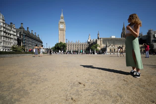
Grassy lawns have dried up after weeks of no rain (Photo: Xinhua News Agency via Getty Images)
British weather has definitely taken a more terrifying turn over the last few months in particular – but just what is causing these sudden fluxes in the climate?
A record-breaking heatwave in July saw the temperature reach an astonishing high of 40.3C, while a longer, albeit slightly cooler, heatwave swept over the UK just a month later.
Now, there are forecasts of rain and thunderstorms which could cause further disruption, with flood alerts issued across multiple regions.
While this is obviously caused by the climate crisis, here’s everything you need to know to understand how it is really affecting our day to day lives.
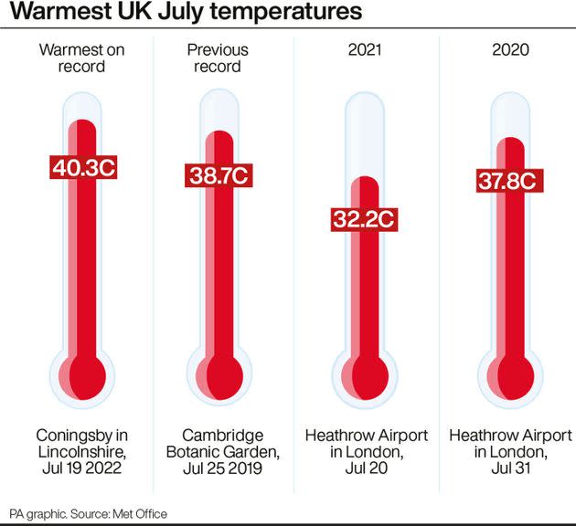
(Photo: PA Graphics via PA Graphics/Press Association Images)
What caused the hot weather?
The extreme weather which spread across the UK in July was caused by a surge in continental air and August’s heatwave has been caused by a “stubborn area of high pressure sat over the UK”, a Met Office spokesperson told HuffPost UK.
A heat-health alert from the UK Health Security Agency is also still in place until 9am on Tuesday.
The heatwaves have made the UK so dry, that an official drought was declared in eight areas of England on Friday by the National Drought Group.
Welsh Water, Southern Water, and South East Water have brought in hosepipe bans too, while Yorkshire Water and Thames Water are planning to bring them in soon.
The Met Office also believes, despite the coming rain, this summer will be remembered as a particularly dry one.
The chair of the National Fire Chiefs Council, (NFCC) Mark Hardingham said: “I can’t remember a summer like this and I’ve been in the fire service 32 years. We are not going to see temperatures as hot as we saw three weeks ago but that doesn’t matter because the ground couldn’t get any drier than it already is.”
Will there be rain?
Not just rain, but storms too. Locations in Northern Ireland and Scotland are already seeing thundery skies, meaning the Met Office has issued some yellow thunderstorm warnings. Storms are expected to hit the south by Wednesday.
Three days of heavy rain are expected in total, potentially accompanied by hail, sweeping in an eastern direction across the country.
The Met Office expects to see at leat 50mm of rain in two or three-hour periods in a few regions, putting low-lying roads and areas next to sloping fields at risk.
But, the rain recorded from the rest of the summer in parts of southern and central England is less than a quarter of what is usually expected in a British summer.
By Thursday, high pressure will have pushed into the UK and so it will stay mostly dry.
Thunderstorms moving in over Ben Wyvis @metoffice@highlandweather@SeanBattyTVpic.twitter.com/QFrWW3nkek
— John Gregory (@Northscotland) August 14, 2022
Is this rain good or bad?
Well, there hasn’t been substantial rainfall since June in many southern regions.
But there are fears that the intense dry spell – lasting several weeks now – means the land is too dry to absorb the rainwater.
There could therefore be flash flooding, but the rain will do little to ease drought conditions. The thunder could could cause power cuts too.
However, rain does still reduce the threat of wildfires which have strained UK fire services over recent months.
The Met Office’s Dan Stroud said what we really need is “an extended period of light rain, an average or slightly above average autumn”, along with a winter where constant light rain recharges the ground.
Discussing the upcoming downpour, Stroud said: “It will help a little but to be honest really, it’s almost the wrong kind of rain. What we’re likely to see is some heavy, intense downpours.
“With the ground baked so dry, it’s very difficult for the ground to actually absorb the water very quickly... so what tends to happen in these circumstances is the water runs off, and we can potentially get some surface run-off issues, so some flash floods.”
Why is our weather changing so quickly?
Short answer: climate change.
In terms of why this week in particular seems so dramatic, meteorologist Stroud said the drastic changes stem from an alteration in air pressure.
Stroud said: “We’ve had a number of days now where we’ve had clear, strong skies and strong sunshine which has heated up the ground.
“We’ve had high pressure dominating, now we’re having low pressure dominate, so the air is becoming more unstable.
“As we’ve had some very high ground temperatures, it doesn’t actually take too much for the air to become even more unstable and for thundery showers to develop quickly.”
Heavy, thundery rain at first across Northern Ireland and Scotland this Monday morning ⛈️
Drier elsewhere, but thundery rain soon spreading from the west, feeling very warm and muggy for many 🌡️ pic.twitter.com/gVXOzUrduE— Met Office (@metoffice) August 14, 2022
Is this a one-time thing?
Probably not. The climate crisis is not going anywhere, and is actually getting worse, as our atmosphere continues to heat up.
Temperatures are expected to decrease to a more normal level in August, but that doesn’t mean we can’t expect similarly searing heat next summer.
As professor Hannah Cloke, a natural hazards researcher at the University of Reading told the i newspaper: “With average temperatures rising across the UK, we have to shift the definition of what ‘particularly hot’ is, otherwise that definitely becomes increasingly meaningless.”
She said the UK needs to change how we define a heatwave, as rising greenhouse gas emissions mean higher temperatures are more common now than they were over the last two decades.
This article originally appeared on HuffPost UK and has been updated.
