
 Yahoo News
 How the Glastonbury Festival site would look if it was held in areas across Surrey
Festival-goers woke up on Worthy Farm’s hallowed Glastonbury fields after a weekend of dancing and partying to the likes of 2024 headliners Dua Lipa and Coldplay. Now the world-renowned music festival has been held, organisers are turning their thoughts to the clear-up job at hand.
For just a few days a year - and not every year at that, due to fallow years - the Somerset farm is estimated to become the most densely populated place on earth. The 2024 event is understood to have had a capacity of around 210,000 - up 30,000 in the space of a decade - with people spread across a site that measures around 1,000 acres.
It can be hard to comprehend quite how this sprawling city of tents and stages compares, though - especially for those unable to get their hands on the notoriously elusive tickets. Enter a new map that allows you to overlay the festival site on any area in the UK, including the biggest towns and most rural villages in Surrey.
Read more: Multi-million pound restaurant and bar opening just a stone's throw from Surrey
Both Dorking and Cranleigh for instance would, with the exception of a few streets, fit inside the Glastonbury footprint. Gatwick Airport on the Surrey border could also fit within the festival grounds, with just a car park and the end of the runway protruding outside of the imagined fences of the relocated Glastonbury.

The Glastonbury borders overlayed on Guildford show the festival would encompass the whole town centre from the River Wey and the High Street north to Ladymead. It would also cover the whole of Stoke Park where Guilfest made a triumphant return at the weekend.
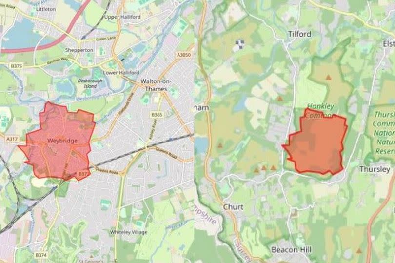
The Glastonbury Festival site is so huge that it would engulf much of Hankley Common and is actually bigger than Weybridge. Chertsey, Addlestone, and Hersham nearby would also provide similar matches to the enormous scale of the festival site.

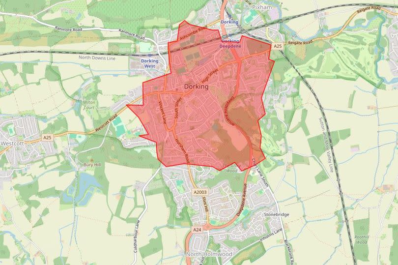
The Glastonbury overlay shows the festival would cover the majority of Dorking. This includes from Dorking Deepdene railway station, the entire town centre and High Street, to residential areas near Horsham Road and The Glory Wood close by.
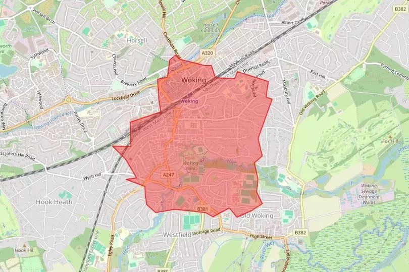
An area equivalent to the Glastonbury site at Worthy Farm would stretch from the Basingstoke Canal in Woking into the Old Woking area, according to the map overlay. This would include the town centre, Woking Park, and nearly reach to the River Wey.
Find out more about things to do and activities in Surrey with our free What’s On email HERE.

