
 Yahoo News
 Hour-by-hour Cornwall forecast - exact time thunderstorms will hit today
Cornwall is set to be hit by a bout of thunderstorms, amid a severe weather warning issued by the Met Office. People living in towns across Cornwall can expect heavy showers and storms throughout Tuesday afternoon (May 21), and possibly into Wednesday (May 22).
There's also the possibility of hail and lightning strikes across the region. The Met Office warns that these conditions may make driving difficult, with potential power cuts and flash floods. The weather warning is in place from 12pm-9pm today across parts of Cornwall, Devon, Somerset and Dorset.
Heavy showers are expected at around 11am, according to current predictions. Rainfall may be patchy but is expected to be heavy and meteorologists suggest that up to 50mm could fall within just a few hours across the region. Lightning strikes and hailstorms are also possible.
Read more:
The Met Office said: "Heavy showers and thunderstorms are expected to develop during the afternoon across parts of southwest England before slowly dying out during the evening. Many places will miss the worst, but where they do develop, some slow-moving and intense downpours are possible, giving accumulations of 20-30 mm in around 1 hour, and a lower likelihood of 40-50 mm in 2-3 hours in a few locations. Frequent lightning strikes and hail are also possible."
Most of Cornwall will be affected by bad weather throughout the day, though not everywhere will see - or hear - thunderstorms. When not experiencing possible hailstorms or downpours, many towns will see lots of bright sunshine.
Hour-by-hour Cornwall thunderstorm forecast
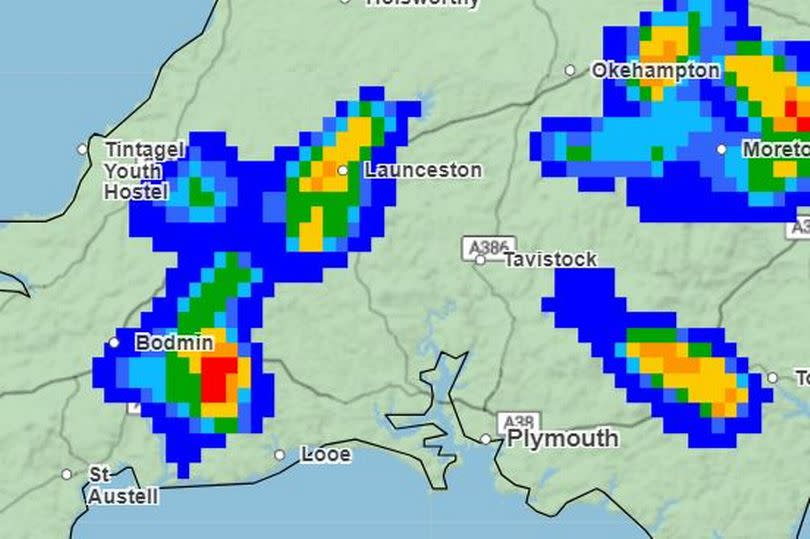
11am - The first of the thunderstorms predicted in Launceston. Rain is yet to begin and skies are clear and sunny in the region. Temperatures sitting between 14C in the west to around 17 in the east.
12pm - Thunderstorms in Launceston and Bodmin. Heavy rain moves in Launceston as well as between Bodmin and Newquay. Further showers at Penare and Pendeen on the coasts.
1pm - Thunderstorms at Bude and Bodmin. Rain moves south of Bodmin, now between St Austell and Liskeard. More heavy rain for Bude and parts of the coast. Temperatures sitting between 14C and 18C.
2pm - Thunderstorms in Launceston. Heavy rain expected in patches across East Cornwall and the border with Devon, with some showers near St Austell.
3pm - Storms expected in Falmouth, Looe and Launceston. Downpours also expected in these three locations, as well as towns which border Devon. Temperatures staying consistant.
4pm - Truro, Bodmin and Looe set to see thunderstorms. Rain finally expected to move eastwards.
5pm - Thunderstorms in Bodmin, though no rain predicted. Showers expected in Looe and Launceston but sunshine and clear skies will return for most of the county.
6pm - No more storms predicted. A few brief showers remain through the rest of the evening, but the skies are expected to remain dry until the early hours of Wednesday morning.
Met Office South West forecast
Today
Early low cloud clearing through the morning to leave sunny spells with scattered showers developing into the afternoon, these turning heavy or thundery especially across parts of Devon and Cornwall. Maximum temperature 20 °C.
Tonight
Showers will ease during the evening, with most places becoming dry with clear spells overnight. Some low level cloud developing across parts of Devon and Cornwall later. Minimum temperature 8 °C.
Wednesday
A dry and bright start with any low level cloud soon to break up and clear. Showers once again developing but are expected to be less heavy than today. Maximum temperature 19 °C.
Outlook for Thursday to Saturday
Largely dry and fine on Thursday and Friday with just the odd shower around. Saturday likely to start dry but showery rain is expected to arrive later in the day.

