
 Yahoo News
 When Kent sunshine will return as week of rain and thunder forecast

Following a weekend of glorious high temperatures and sunshine, grey skies and rain have once again returned to Kent. Some parts of the UK saw the mercury rise up to 26C over the weekend, and while temperatures will primarily keep warm over the coming weeks, persistent showers and even some thunder sit on the horizon.
The latest Met Office forecast predicts that here in the south east, after some outbreaks of rain throughout Kent this morning (Tuesday, May 14), conditions will turn mostly dry by the late afternoon. Temperatures will peak at around 19C, before rain showers return overnight, particularly to the east of the county.
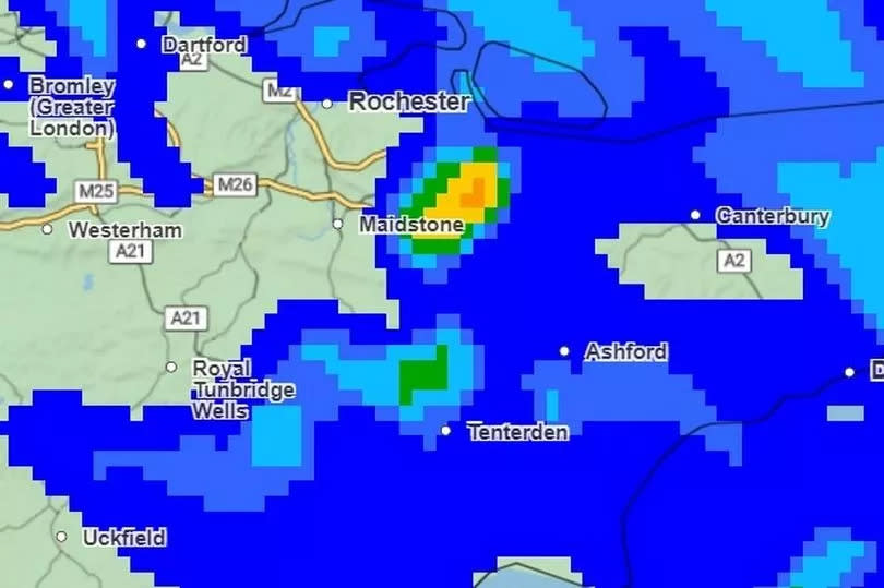
Weather maps show the heaviest showers developing in the early hours of Wednesday morning between 3am and 5am, with the likes of Maidstone, Ashford and Medway to see the most rain. While there is the possibility for some sunnier clear spells throughout Wednesday, forecasts warn of cloudier skies and further rainfall for Kent across much of the day.
Read more: Northern Lights possible again after 'final blast' solar flare
Read more: Disruptive Kent coastal roadworks could end two months early
Expect a rather humid feeling day amid the showers, as temperatures are expected to peak at around 20C. The Met Office goes on to predict a mixed bag of weather between Thursday and Saturday, with warm sunny spells broken up by more rain.
Such showers may turn heavy in some areas, with a chance for thunder at times. Similar predictions have been shared by the BBC, with forecasters noting a mixture of cloud, sunny spells and rain on Thursday.
Friday will likely be the clearest day at the end of this week, with more sunshine than previous days and a reduced risk of showers here in Kent. However, the favourable conditions will not last long as a spell of cloud and rain will arrive from the east on Saturday, bringing some thunder with it.
Unfortunately, the forecast is not looking much brighter from here on out either, with the heaviest rain and greatest risk of thunderstorms predicted between Saturday, May 18 and Monday, May 27. The Met Office long range forecast for this period states: “On balance a continuation of the showers in the south seems most likely, with the north continuing to see the best of any drier weather. Temperatures probably remaining a little above average.”
Looking yet further ahead, The Met Office notes that confidence lowers for the period between Tuesday, May 28 and Tuesday, June 11 but once more rainy weather is likely for us here in the south. The forecast goes on: “By early June, the chances of above and below average rainfall are evenly balanced.
“There is a slightly higher likelihood of above average temperatures compared with below average temperatures, such that the chance of hot spells, although still very small, is slightly higher than normal too.” While over 30 flood alerts are currently in place across the UK, no new alerts or warnings have been issued for Kent thus far.
An alert for groundwater flooding that blankets the entirety of east Kent remains in place however. Prolonged spells of heavy rain seen throughout the start of 2024 resulted in high groundwater levels which still have not fully reduced and are likely to be worsened by the coming wet weather.
The Environment Agency added: “Although groundwater levels in East Kent have shown a slow but steady decline since mid-April, the Alkham Bourne and the Nailbourne between Lyminge and Littlebourne are still flowing. At this point in time, localised flooding still continues to affect low-lying land, roads, and water infrastructure around the Elham Valley, Alkham and Petham. Other communities in East Kent may also still be impacted. Please avoid walking or driving through flood water.”
There also remains an ongoing flood alert for the Nailbourne and Little Stour near Canterbury due to persistent increased river levels caused by prolonged rainfall. The EA added: “We are actively monitoring the situation, liaising with partners, and our staff are maintaining and clearing key structures. The Littlebourne Flood Relief channel is still operating."
Get more news from KentLive straight to your inbox for free HERE.

