
 Yahoo News
 Maps show dramatic weather shift just days after mini-heatwave
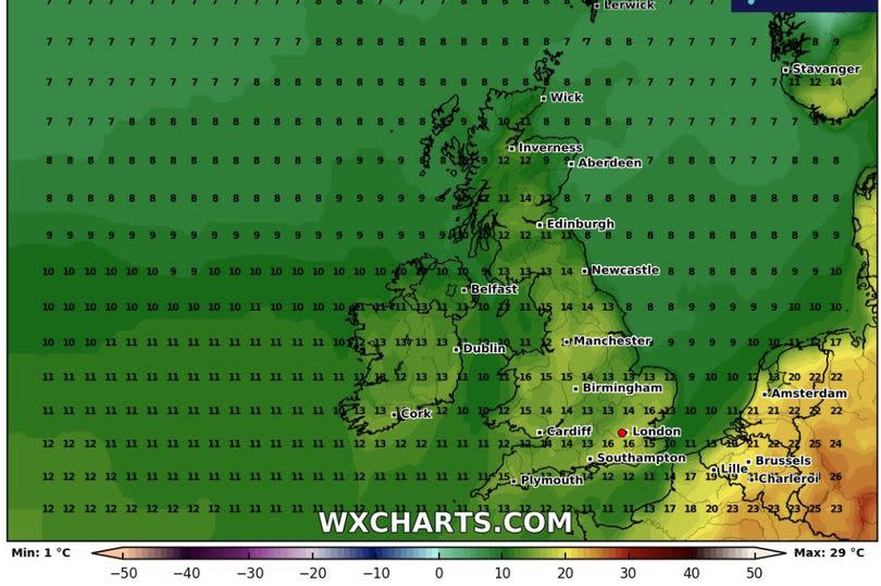
Weather maps show the UK turning blue just three days after 16C mini heat blast. Brits are set to experience a dramatic drop in temperatures - by as much as 20C - in just three days, according to the latest weather maps.
The Mirror reported that next Thursday and Friday will be particularly warm - following a cold slump in the coming days. A north-south divide is still largely expected on Thursday, with warmer temperatures generally anticipated across northern regions.
Read more: Beauty fans can get Molly-Mae Hague's favourite skincare product for 'free' with Boots deal
Get breaking news on BirminghamLive WhatsApp, click the link to join
The temperature is likely to reach a peak of 16C on both days but, by Friday, southern areas will bask in the warmer weather as the wind direction suddenly changes. Metdesk's weather maps indicate that Greater London, Surrey, Hampshire and parts of Essex will enjoy the best of the weather by the end of the week.
However, a topsy-turvy forecast for the weekend will eventually see temperatures plummet - to below freezing on the morning of Monday May 6, our next bank holiday.
Metdesk's map for this day paints a picture of blue, signifying colder conditions as the wind is likely to blow in from the North Sea. Many will wake up to temperatures below freezing and ground frost, notably across north Wales, Cumbria, parts of Northeast of England and most of Scotland, reports the Mirror.
It'll be as chilly as -4C in and around Edinburgh, according to Metdesk, which is a massive 20C drop from the 16C highs many in the south are likely to experience just three days prior.
Temperatures soared to 16C in Plymouth, Devon on Wednesday, while the East of England saw a chillier day with Shoeburyness, Essex just hitting 11C.
The Met Office suggests that the unpredictable weather is set to continue throughout May.
Regarding the forecast from Friday, May 10 to Friday, May 24, the Met Office website states: "In this period, the chances of unsettled weather are slightly less than usual in the north and about the same as usual further south."
It adds: "Therefore, some spells of wetter weather are likely for all, but perhaps especially southern areas with the driest conditions probably further north. Temperatures probably near average though with some cooler interludes possible. Also worth noting that average temperatures themselves rise by around 1C per week at this time of year."

