
 Yahoo News
 Met Office forecasts Kent temperatures above 20C as weeks long 'heatwave' possible

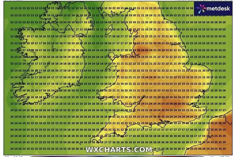
After what has been a particularly gloomy and damp start to June, the weather may at long last take a turn for the warmer in the coming weeks. Current forecasts from WX Charts predict temperatures climbing comfortably to the 20C mark and beyond throughout the final week of June.
Between Monday, June 24 and Thursday, June 27 Kent could feel peaks of up to 20C, with afternoon temperatures primarily sitting in the high teens for much of this time. Then on Friday, June 28 temperatures are looking to creep a little higher to around the 21C and 22C mark, with the warmest weather likely toward the north of the county in Medway, Maidstone, Dartford and Gravesend during the late afternoon and early evening.
A continuation of this trend is then forecast for the final weekend of the month, when temperatures will rise up to 23C in parts of the county on Saturday, June 29 and Sunday, June 30. This warm spell could come as the result of an expected high pressure build-up arriving in the UK from Europe in the coming weeks, breaking the recent trend of chillier temperatures brought about by persistent low pressure.
Read more: 'Concerned' Kent Police officers are searching for boy
Read more: Palestine protesters storm Kent factory and vandalise bank HQ
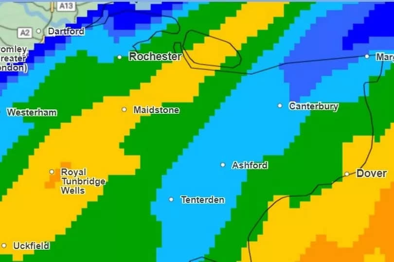
During this week-long period, WX Charts predicts very little rain over Kent, with the county potentially in for a full week of dry weather. Light rain showers are not expected over the county until the early hours of Monday, July 1.
Before the arrival of these more favourable conditions however, the south could face more rain and even some thunderstorms. The long-range Met Office forecast for Friday, June 21 to Sunday, June 30 states: “There remains a small chance of an area of heavy, thundery rain affecting parts of the south on Friday 21st, possibly accompanied by briefly hot and humid conditions.
“Into the last week of June, changeable conditions are likely to remain dominant, with the focus for these conditions continuing to be across the north and west, with spells of more settled and drier conditions likely in the south and east. Nationwide, temperatures are expected to be close to or slightly above average.”
Today (Monday, June 17), the Met Office forecasts skies turning cloudier toward the late afternoon, with the chance for some scattered rain showers. Fine weather and clear spells are then expected into the evening and overnight, with the emergence of occasional fog patches as temperatures drop to lows of 7C.
Tuesday will then see a fine start, with any fog soon clearing, followed by some hazy sunshine and the risk of heavier rain spells across Kent. Met Office weather maps show downpours covering the entirety of Kent from around 12pm, persisting throughout much of the early afternoon before mostly clearing by 3pm.
Clear skies and dry spells are likely as we approach dusk, with temperatures peaking at around 23C. More fine weather and sunshine has been forecast for Wednesday, and during the start of Thursday.
However, from here there is an increasing chance for some thunderstorms, which are perhaps most likely to arrive on Friday. Temperatures will peak at around 20C and 21C on Friday and across the weekend, with such temperatures expected for all of Kent on Sunday afternoon.
Get more news from KentLive straight to your inbox for free HERE.

