
 Yahoo News
 Met Office issues thunderstorms warning after two days of high temperatures

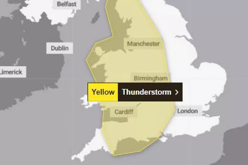
Make the most of the warm temperatures and sunshine today and on Saturday, as a warning for thunderstorms has been issued for the whole of Wales on Sunday. The warning is in place from noon until midnight indicating a change in the weather.
It comes as the forecasters say Friday could be the warmest day of the year so far as high pressure continues to take charge of our weather.
Highs of 25°C are possible on Friday (May 10) and could reach up to 26°C in the south on Saturday and Sunday, the Met Office says. BBC Weather says: "More warm and sunny weather on the way! Temperatures on Thursday reached 24.6°C at St James's Park London, the highest temperature of the year so far. Today, 26C looks possible and temperatures this weekend could hit 27°C."
READ MORE: Met Office says Wales set for hottest day of the year
READ MORE: Residents claim Roath Lake in Cardiff is becoming a 'fetid swamp'
But there is set to be a big change on Sunday as an area of low pressure heads towards the UK.
The warning, that covers the whole of Wales, says: "Heavy showers and thunderstorms are likely to break out in the south of this area late Sunday morning and early Sunday afternoon, moving steadily north whilst growing into larger areas of rain before clearing the area."
It adds: "Some intense downpours are possible in a few places, giving up to 30 mm in less than hour and perhaps 40-50 mm over two to three hours leading to surface water flooding. Hail, frequent lightning strikes and strong wind gusts will be additional localised hazards."
In a forecast for the whole of the UK, deputy chief meteorologist Tony Wisson said: “Many places will start fine and warm on Sunday, though it is likely to become cloudier from the west or southwest during the day. This will be accompanied by scattered showers, which could be heavy with thunder.
“On Monday we're likely to see more widespread and longer-lived spells of rain, some of which will be heavy and thundery. This will also lead to a much cooler feel to the day.”
The UK long-range forecast for Tuesday, May 14, to Thursday, May 23, says: "The weather is expected to change from the current warm and settled conditions, with a return to an unsettled and showery pattern as low pressure comes to dominate. Rain and showers, locally heavy and thundery, are expected across much of the United Kingdom. Rainfall amounts could be above average in many areas, most likely where showers merge with each other and become very slow moving."
It adds: "Winds could be fresh at times, especially near heavier showers and also along coasts. Temperatures will not be as high as in the preceding week, and are expected to fall closer to average for May, and feeling rather cold where it remains damp and cloudy. However it will feel much warmer in any sunny spells."

