
 Yahoo News
 Met Office says Wales set for hottest day of the year and it could get even better

Friday could be the warmest day of the year so far as high pressure continues to take charge of our weather. For the first time in months the weather map for the whole of the UK shows clear skies with no rain.
Highs of 25°C are possible on Friday (May 10) and could reach up to 26°C in the south on Saturday and Sunday, the Met Office says. Temperatures hit highs of 22°C in Cardiff on Thursday afternoon, with Welsh weather presenter Derek Brockway declaring it was the warmest day of the year so far in the capital. Meanwhile, it was only 13°C in Trearddur Bay on Anglesey with sea fog.
READ MORE: The number of people caught breaking Wales' 20mph speed limit is rising
READ MORE: Residents claim Roath Lake in Cardiff is becoming a 'fetid swamp'
BBC Weather says: "More warm and sunny weather on the way! Temperatures on Thursday reached 24.6°C at St James's Park London, the highest temperature of the year so far. Today, 26C looks possible and temperatures this weekend could hit 27°C." The Met Office forecast for Wales on Friday says that it will "stay dry with plenty of warm sunshine". For the latest Welsh news delivered to your inbox sign up to our newsletter
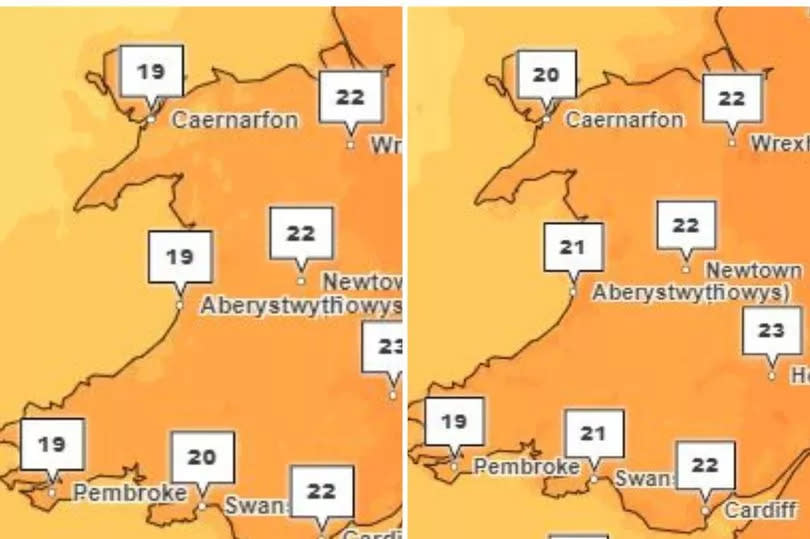
A full Friday forecast says: "High pressure continues to dominate, bringing a dry day with plenty of sunny spells, although perhaps the odd shower in the north through the afternoon. Feeling very warm in the sunshine. Maximum temperature 22 °C.
"Staying dry overnight with clear spells across the country. Light winds will allow some patchy mist and fog to develop by dawn. Minimum temperature 8 °C."
Saturday looks set to stay the same with the forecast for Wales saying: "Remaining dry to start the weekend with blue skies and prolonged sunshine. Feeling pleasantly warm with light winds. Maximum temperature 23 °C."
Weather conditions are expected to return to a more unsettled pattern as we head into the new working week. Rain and showers will start to move in from the west, due to a developing low pressure system from the Atlantic.
Deputy chief meteorologist Tony Wisson said: “Many places will start fine and warm on Sunday, though it is likely to become cloudier from the west or southwest during the day. This will be accompanied by scattered showers, which could be heavy with thunder.
“On Monday we're likely to see more widespread and longer-lived spells of rain, some of which will be heavy and thundery. This will also lead to a much cooler feel to the day.”
BBC Breakfast presenter Simon King says that low pressure will once again take charge bringing cooler temperatures and the chance of more prolonged rain showers.
The UK long-range forecast for Tuesday, May 14, to Thursday, May 23, says: "The weather is expected to change from the current warm and settled conditions, with a return to an unsettled and showery pattern as low pressure comes to dominate. Rain and showers, locally heavy and thundery, are expected across much of the United Kingdom. Rainfall amounts could be above average in many areas, most likely where showers merge with each other and become very slow moving."
It adds: "Winds could be fresh at times, especially near heavier showers and also along coasts. Temperatures will not be as high as in the preceding week, and are expected to fall closer to average for May, and feeling rather cold where it remains damp and cloudy. However it will feel much warmer in any sunny spells."

