
 Yahoo News
 Met Office map shows 750-mile rainstorm to hit UK as Coventry set for soaking
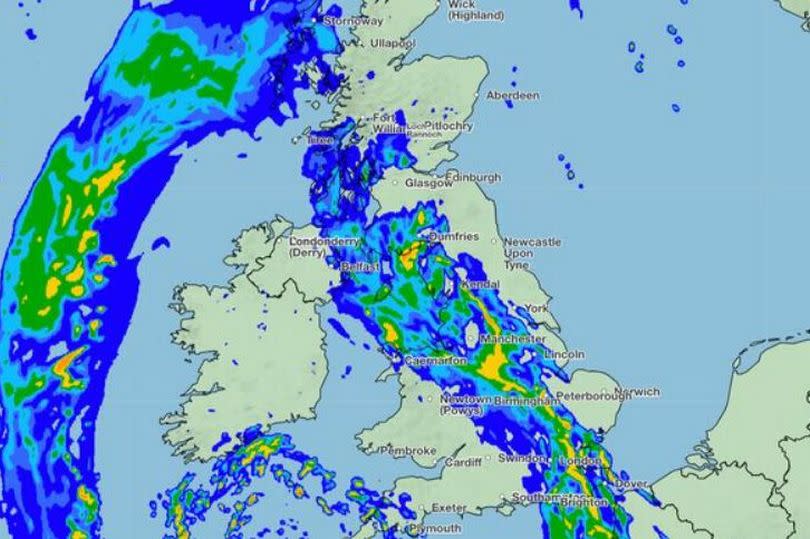
A 750 mile long rainstorm is set to hit the UK tomorrow according to the Met Office's latest map. It will be bring heavy rain for much of the country, including Coventry and Warwickshire.
For some areas there could be up to 6mm of rain per hour, reports the Mirror. While the heaviest rain is set for tomorrow (May 14), the latest local Met Office forecast for our area shows that, after a sunny day today, it is set to turn wet this evening.
Then the 'heavy showers' will hit late this evening and into the morning. It is in stark contrast to the scorching weather over the weekend.
READ MORE: Coventry's only lap-dancing club confirms plans to move
There was a short shower burst across part of our area last night, the first rain we have seen in days. The latest local forecast is as follows:
Today
Some cloud to start but breaking up leaving a dry day with sunny spells, though not feeling as warm as Sunday. Light winds, turning breezier during the afternoon. A chance of some rain in the far west by late-afternoon. Maximum temperature 21C.
Tonight
Turning wet this evening as rain spreads in from the west overnight, this heavy and persistent at times. Winds becoming brisk, particularly amongst heavier downpours. Mild. Minimum temperature 12C.
Tuesday
Heavy rain during the morning, then generally drier by the afternoon with some sunshine, though a risk of the odd shower. Lighter winds and feeling pleasant in the sunshine. Maximum temperature 18C.
Outlook for Wednesday to Friday
Unsettled with sunny spells and showers. Showers may be heavy and possibly thundery at times. Still warm where you catch the sunshine though feeling cooler than last week.
Sign up for our FREE daily newsletter here for all the latest news about Coventry .

