
 Yahoo News
 Met Office thunderstorm and rain warnings surround Gloucestershire
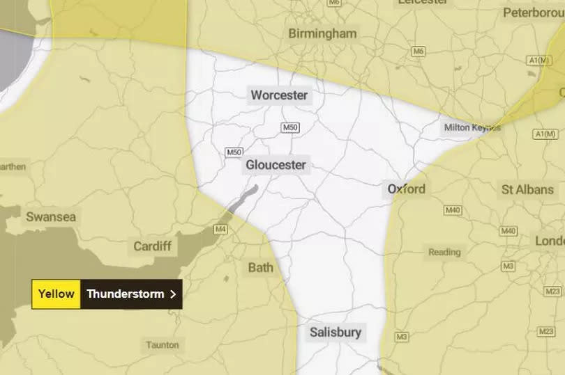
Thunderstorms are set to rock much of England today (Tuesday, May 21) but Gloucestershire looks set to escape the worst of the weather. It's not going to be great in the county, however, with heavy rain now due to fall from 8pm and pretty much carry on until the early hours of Thursday.
The Met Office has issued a yellow weather warning for thunderstorms across parts of the West Country until 9pm today, coming as far as north as Chepstow in Wales and Yate in South Gloucestershire. A yellow rain warning for much of central and northern England comes as far south as Stourport-on-Severn in Worcestershire while another thunderstorm warning for much of the South East of England comes as far west as Oxford.
Gloucestershire as well as parts of Wiltshire and Hampshire remain outside the yellow zones. Anyone from the county heading out towards the West Country or London will face severe weather on stretches of the M5 and the M5.
READ MORE: 'Multiple injured and one dead' after 'severe turbulence' strikes plane after leaving UK
The thunderstorm warning for the South West and west Wales says thunderstorms are likely to develop in places on Tuesday afternoon. This could lead to some travel disruption and surface water flooding.
What to Expect
Spray and sudden flooding could lead to difficult driving conditions and some road closures
Where flooding or lightning strikes occur, there is a chance of delays and some cancellations to train and bus services
There is a slight chance that power cuts could occur and other services to some homes and businesses could be lost
There is a small chance that homes and businesses could be flooded quickly, with damage to some buildings from floodwater, lightning strikes, hail or strong winds
Explaining this weather warning in more detail, the Met Office adds: "In the south of this warning area, the focus is likely to be slow-moving heavy showers and thunderstorms, perhaps with hail and lightning, which should gradually ease away later on Tuesday evening. Meanwhile, further north in the warning area, early showers are likely to merge into more general rain, this heavy and thundery at times, and will persist onwards into Wednesday (which is covered by a separate warning).
"Across the warning area, 20-30mm in 1 hour or less is possible (but perhaps most likely to the south of London), with a few places perhaps receiving 40-50mm in 2-3 hours."

