
 Yahoo News
 Met Office verdict on reports UK to experience '29C North African heatwave'

The latest weather maps indicate when the UK can anticipate its first 29C heatwave of the year. Despite a dreary and unusually chilly start to summer, things could be about to warm up.
Forecasters at Netweather. tv suggest that all hope is not lost, even though we're just five days away from the longest day of the year - marking the slow return of darker evenings. With peak temperatures barely surpassing 25C, there's been no indication of sustained hot weather hitting the UK.
However, a North African plume could reach the country before the month's end. This predicted heatwave is expected to arrive via Europe with a sting in its tail - with June 29 being the penultimate day a red highlight covers the country, indicating a temperature rise.
READ MORE: The Bristol church which has not seen worship in 40 years
READ MORE: How iconic Weston-super-Mare Grand Pier has survived 120 years
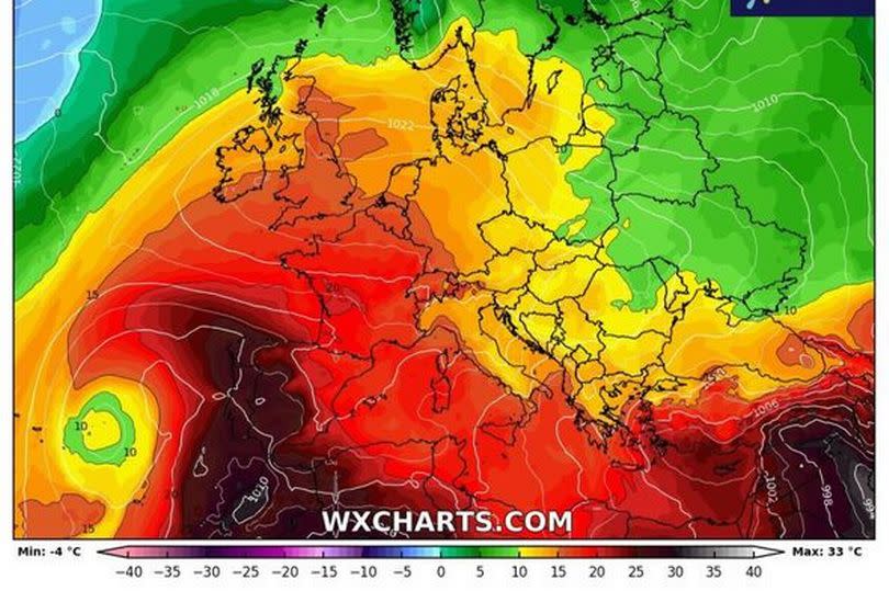
Northern France will bask in a blistering 31C, losing at least two degrees as it crosses the Channel to Britain. The southern coast of England is forecasted to record the highest temperature, with parts of Sussex bracing for scorching highs of 29C, according to the Express.
However, other regions of the country won't be far behind. Counties such as Kent, Essex, Hertfordshire, Cambridgeshire, Greater London, Surrey, and Berkshire are due to experience highs of 28C.
Birmingham and other areas of the West Midlands will swelter in highs of 27C, while Manchester and Liverpool are likely to see 26C. Temperatures will drop further north, with towns and cities near Newcastle experiencing 22C.
Cardiff in Wales is expected to experience a moderate 25C. Despite early positive indicators from weather maps, Netweather forecasters stress that this is not a guarantee.
Forecaster Ian Simpson stated: "There is some chance of some of that North African and southern European heat making its way to the British Isles towards the end of June, depending on whether the ridges of high pressure from the Azores align in such a way that we pull in hot air masses from the south and south-east, but this is not a certainty."
As for how long this will last? Jet streams are never too far away, and there is likely to be a "pattern shift" which will nudge thermometers up slightly as the month goes on.
"Predominantly west to south-westerly winds and ridges of high pressure [will be] moving in from the Azores at times, interspersed with periods of more unsettled weather with low-pressure systems coming in off the North Atlantic," Ian added.
The Met Office's long-range forecast doesn't hint at a heatwave, but it does suggest temperatures are set to rise. Up until June 29 it states: " Into the last week of June, changeable conditions are likely, with the focus for these conditions being across the north and west, with spells of more settled and drier conditions likely in the south and east. Nationwide, temperatures are expected to be close to or slightly above average."
What does the Met Office say?
The Met Office's long-range forecast doesn't hint at a heatwave, but it does suggest temperatures are set to rise. Up until June 29 it states: " Into the last week of June, changeable conditions are likely, with the focus for these conditions being across the north and west, with spells of more settled and drier conditions likely in the south and east. Nationwide, temperatures are expected to be close to or slightly above average."
Met Office West Country forecast
This Evening and Tonight: Any daytime showers will fade to leave a largely dry night, with clear spells developing for many. Turning locally chilly, with some mist and fog patches forming in rural areas. Minimum temperature 4 °C.
Monday: Early mist and fog patches soon clearing to leave another day of sunny spells and scattered showers. However, some places will escape largely dry throughout. Feeling a little warmer. Maximum temperature 19 °C.
Outlook for Tuesday to Thursday: Largely dry with sunny spells on Tuesday and Wednesday, although a few well-scattered showers are possible. Dry with variable cloud and sunny spells on Thursday. Temperatures near average.

