
 Yahoo News
 Not over yet: Historic atmospheric river won't be the last of the rain in California
As California residents reel from the lingering effects of a deadly storm that prompted a state of emergency, AccuWeather meteorologists are tracking the next storm expected to swing through the state this week. While less intense than its predecessor, the storm will bring additional rain and wind to the region that can slow cleanup efforts and the recession of floodwaters.
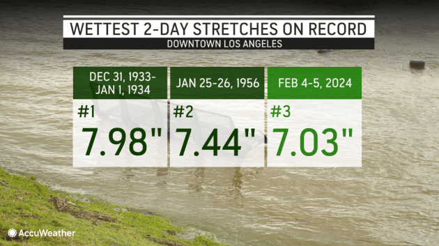
Over Sunday and Monday, downtown Los Angeles received 7.03 inches of rain, marking the third wettest two-day span in the city's history, as well as back-to-back days of a daily rainfall record being broken. To put this event in perspective, the 30-year historical average seasonal rainfall for the downtown area is 14.25 inches.
 |
The destructive storm sent mud, boulders and debris down hillsides and roadways across the region as the heavy rain prompted torrents of water to rush downstream, carrying away objects from people's homes and yards.
AccuWeather estimates that the preliminary total damage and economic loss from the intense storms and record rainfall in California this week will be between $9 billion and $11 billion.
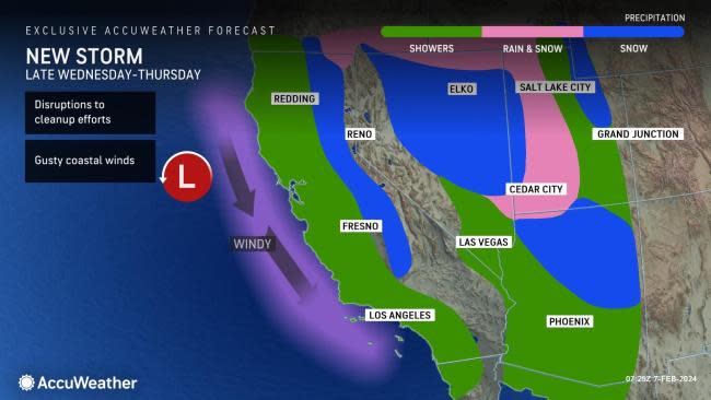
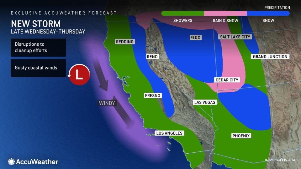
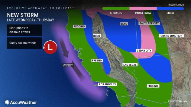
At midweek, the historic storm that brought devastation to Southern California was slowly pivoting inland across the southwestern United States. Meanwhile, a new storm began to drop southward off the coast of western Canada. The storm began to pummel Northern California first thing Wednesday morning with low-elevation rain and mountain snow.
"This more compact storm dropped southward near the California coast through Wednesday night, bringing several hours of rain along its path," AccuWeather Senior Meteorologist Heather Zehr said.
Because this next storm will be moving in from the north, as opposed to the south and southwest, there will be fewer concerns of extreme rain amounts.
"This storm path cuts off any tropical connection which led to the excessive and destructive conditions over the past several days," Zehr said. "The prevailing wind direction also won't help to enhance the rain like we saw with this last storm."
 |
For many along the California coast and parts of the Central Valley, rain amounts with the latest event are expected to tally 0.50 of an inch to an inch through Thursday.
However, some of the south- and west-facing slopes of the Coast Ranges can pick up a couple of inches of rain. The wet weather will be quick-hitting, lasting less than 12 hours in most areas.
Given the saturated nature of the soil, any additional rain will quickly run off and can result in localized incidents of renewed flooding.
"The rain can also cause a return of standing water in areas that see some improvement," Zehr said.
More common impacts across Southern California will be for the storm to disrupt cleanup efforts and cause ponding of water on roadways as well as slow travel.
Motorists venturing into the higher elevations of Southern California will run into wintry trouble from the storm.
 |
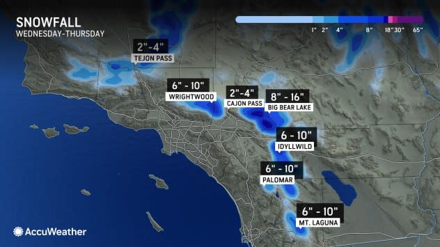
"Snow levels will lower into Thursday and that will translate to heavy snow in the mountains of Southern California," AccuWeather Chief On-Air Meteorologist Bernie Rayno said.
The storm will bring several inches of snow to the passes along Interstates 5, 10 and 15 with up to a foot or so of snow for the ridges and peaks.
Wind gusts of 20-35 mph can occur along the coast and in the mountains of Southern California. While these winds are not nearly as strong as what occurred over the weekend and earlier this week, AccuWeather meteorologists say that they can still result in toppled trees and power lines due to the saturated ground.
Stray showers of rain and high-elevation snow can continue in Southern California at the end of the week before a much-needed dry weather pattern moves in this weekend and lasts into the middle of the month.
Want next-level safety, ad-free? Unlock advanced, hyperlocal severe weather alerts when you subscribe to Premium+ on the AccuWeather app. AccuWeather Alerts™ are prompted by our expert meteorologists who monitor and analyze dangerous weather risks 24/7 to keep you and your family safer.
