
 Yahoo News
 Slow improvement follows massive weekend rainstorm in Midwest, Northeast


A storm responsible for producing rain from the foothills of the northern Rockies to the mid-Atlantic and southern New England coasts will move out to sea into Monday. However, AccuWeather meteorologists say that following improvement, another storm will have to be watched for part of the East Coast this upcoming weekend.
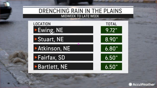
The storm deposited 6-10 inches of rain on parts of Nebraska and South Dakota into Friday night.
 |
This weekend, a strip where 1-2 inches of rain fell extended across part of the Midwest and into the central Appalachians. That rain then penciled out to 0.50 of an inch to 1 inch across the upper mid-Atlantic coast, including the New York City area.
The same storm system had its moments for severe weather as well over parts of the Plains and Mississippi Valley from Thursday afternoon to Friday evening. Storm spotter and radar debris signatures indicated that five tornadoes had occurred in south-central Nebraska Thursday.
The rain has generally been welcomed over the north-central United States, where many locations have struggled with moderate to extreme drought conditions in recent weeks and months. The lack of rain for so long has many streams and rivers running extremely low. Barge operations on the Mississippi River have been significantly reduced due to the narrowing and swallowing of the navigation channel.
While some runoff from the rainstorm will eventually work into the Missouri, upper Mississippi and Ohio rivers, any bump in water levels may only be slight and brief in the coming weeks.
On Friday afternoon, there were no official tornado touchdowns, but multiple funnel clouds were observed by spotters in Iowa.
Weak tornado just crossed I-80 near Newton! @NWSDesMoines #iawx pic.twitter.com/wgPHt8xOCo
— Trey Fulbright KCCI (@TreyKCCI) October 13, 2023
As the storm moves out to sea and an associated dip in the jet stream takes up residence in the eastern third of the nation, a pattern more fitting for the middle of November will take hold for a couple of days.
 |
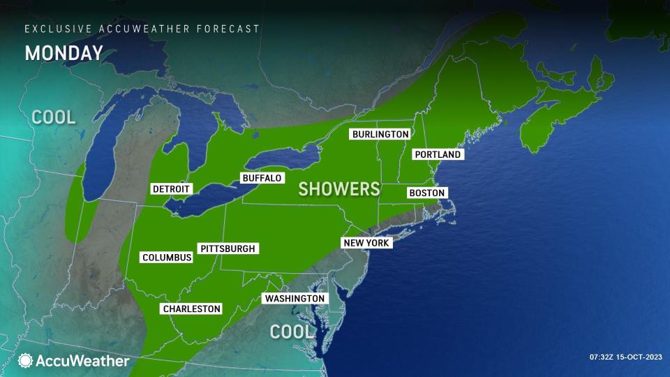
A regime of clouds and showers with brisk and chilly conditions will sprawl from much of the Midwest to much of the Northeast into Monday.
Daytime highs in Midwest cities such as Chicago, Detroit and Cleveland will be in the 50s through Monday, compared to historical averages in the 60s. In the coastal Northeast, highs will be within a few degrees of 60 from Boston to New York City and Washington, D.C., through Tuesday.
Cloud cover and/or an active breeze at night will prevent temperatures from dipping to frosty levels in most areas. But, factoring in the breeze, both daytime and nighttime temperatures will feel 5-15 degrees lower than the actual temperature.
The same pattern will send a record-challenging chill into Florida and may trigger the first snowflakes of the season over the highest terrain of the southern Appalachians.
 |
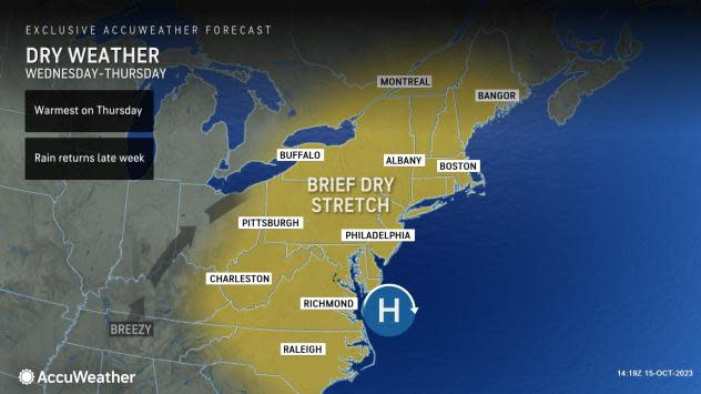
"High pressure will build over the East Coast by the middle of the week, ushering in a brief stretch of dry conditions," AccuWeather Meteorologist Alyssa Glenny said. "Sunshine can expand across the Ohio and Tennessee valleys by Wednesday as calmer conditions take over."
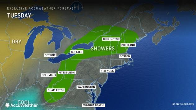
From Wednesday to Thursday, a zone of low pressure may dive southward from central Canada and bring the return of damp, chilly weather to parts of New England and the mid-Atlantic region after some drier weather Tuesday, Glenny added.
 |
It is possible that the effects of this storm system may be reduced and limited to a zone of clouds and only very spotty showers.
Rainfall totals continue to be gathered with the current storm in the East. However, with the current storm, it has rained every weekend in New York City after the dry Labor Day holiday. A storm next weekend would make it seven in a row. New York City has received 16.40 inches of rain from Sept. 8 through Oct. 15, which is nearly three times that of the historical average. Much of that rain has fallen on the weekends.
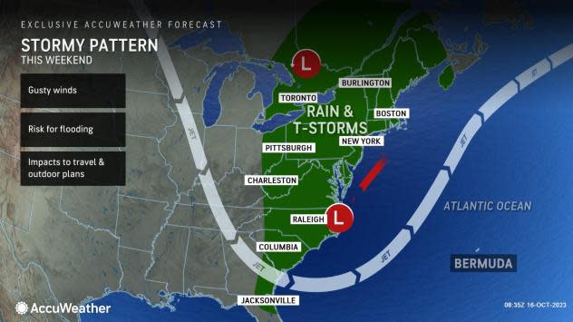
AccuWeather meteorologists have been tracking energy associated with the former Super Typhoon Bolaven. As this system, as a tropical wind and rainstorm, curves northward and toward Alaska in the coming days, it will cause the jet stream to buckle a second time and in such a way as to conjure up stormy conditions in the eastern third of the nation during the weekend of Oct. 21-22. This typhoon recurve teleconnection, as it is called, has been well-known by AccuWeather meteorologists for decades.
 |
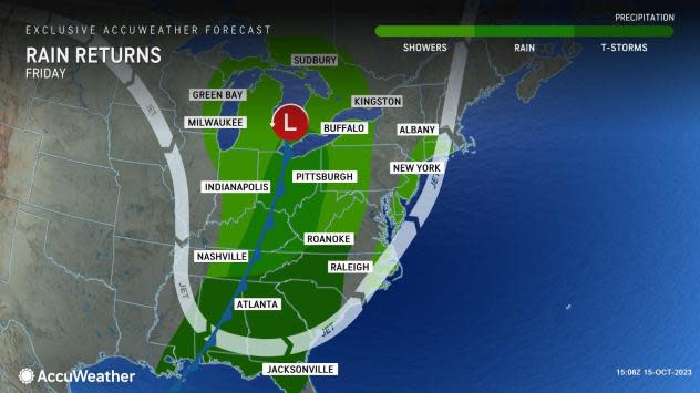
A zone of showers and embedded thunderstorms will pivot steadily across the Midwest and Southeast states Friday. The forward progression of that storm may slow as it nears the Atlantic coast.
While moisture will likely gather as a storm forms along the East Coast this upcoming weekend, the timing, track and extent of that storm with its rain and wind may not be fully known until several days beforehand.
"This storm will have the potential to spread gusty winds and heavy rainfall along the coast as it churns northward the upcoming weekend," Glenny said.
 |
It is possible that the same dip in the jet stream likely to spawn a coastal storm may work to keep a budding tropical system over the Atlantic that could evolve into a hurricane well away from the United States next weekend. However, that system could pass close enough to be a threat to the northeastern Caribbean.
Want next-level safety, ad-free? Unlock advanced, hyperlocal severe weather alerts when you subscribe to Premium+ on the AccuWeather app. AccuWeather Alerts™ are prompted by our expert meteorologists who monitor and analyze dangerous weather risks 24/7 to keep you and your family safer.
