
 Yahoo News
 Southwest Newfoundland could see 400 mm of rain this week
The western side of Newfoundland is in for heavy winds and a whole lot of rain over the next three to four days, with floods, washouts and landslides possible.
Wind and rainfall warnings are in effect across much of the west coast, but conditions will be particularly worse for the southwest portion of the island.
Areas like Port aux Basques and Burgeo could see between 100 and 200 mm of rain between Tuesday and Friday, with as much as 400 mm in some specific areas.
"Some of the highest models are showing upwards of 400 mm of rain falling," said CBC meteorologist Ashley Brauweiler during Here & Now Monday.
"If that does happen, it will likely be in the higher elevations, but still, an incredible amount of rain in a small amount of time."
The drastic forecast forced Brauweiler to adjust the scales she uses to show predicted rainfall to TV audiences, because it didn't go high enough.
"These rainfall totals as you can imagine are very significant," she said.
Rainfall rates could exceed 10 mm per hour, and last for several hours.
Environment and Climate Change Canada is warning that a weather system like this can cause flash flooding, road washouts, destruction of bridges, mudslides, landslides and lengthy recovery times.
Port aux Basques Mayor Brian Button said residents and town staff are working to make sure systems that can prevent possible damage are working — but added some can't hold the amount of forecasted rain.
It comes at a time where the town still has some temporary measures in place from post-tropical storm Fiona, which devastated the area in 2022.
"Every time that we get weather, whether it's myself or the community at large, I mean there's a sense of anxiety all the time now," Button said Tuesday.
"Ever since our community went through Fiona and experienced that type of weather, things haven't been the same. We certainly know when there's weather coming in, you can feel it all around the community."

Port aux Basques Mayor Brian Button says residents of the town are preparing for intense amounts of rainfall. (Alex Kennedy/CBC)
Button said the forecast almost feels like deja vu, pointing to a rainstorm that hit the region on Christmas Day last year.
"There's no good time, but this time of year is even worse," he said.
Atmospheric river acts 'like a fire hose'
Marine Atlantic cancelled crossings again Tuesday, and severe weather conditions caused power outages in Port aux Basques, Port au Port, Pasadena and the Corner Brook area.
Several schools in the area either opted to close due to the weather, or were forced to close due to power outages.
Brauweiler said this weather system is expected to continue bringing rain until Thursday or Friday.
"We are tapping into some subtropical or tropical moisture over the next couple of days," she said. "This is setting up kind of an atmospheric river setup, and essentially it's like a fire hose directing rain right towards the province."
Savio Paul, a meteorologist with Environment Canada's Gander weather office, compared it to a pair of storms that caused significant damage to parts of the island.
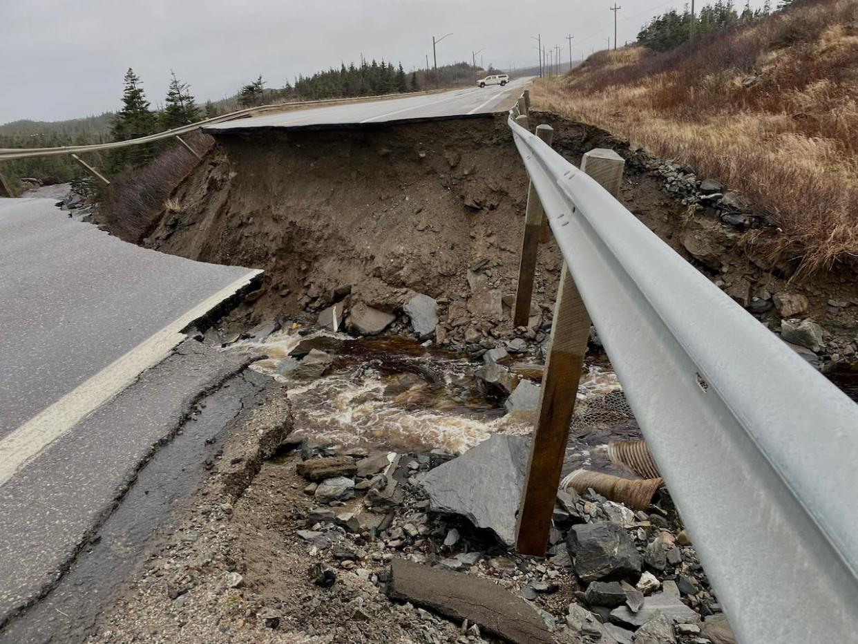
"The impacts to this [southwest] area will be similar to the Thanksgiving storm, if anyone remembers in 2016, or the November 2021 storm that washed out the TCH north of Port aux Basques."
In 2016, the remnants of Hurricane Matthew caused roads and bridges to wash out in western and central Newfoundland, and severed the Trans-Canada Highway in Terra Nova National Park for two days.
In 2021, areas of the Trans-Canada Highway north of Port aux Basques were washed away by about 150 mm of rain, and several communities were isolated by road closures.
Download our free CBC News app to sign up for push alerts for CBC Newfoundland and Labrador. Click here to visit our landing page.

