
 Yahoo News
 Springlike warmth to build over the South Central states this week
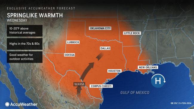


Temperatures will be on the rise this week across the southern Plains, AccuWeather meteorologists say. A northward bulge in the jet stream across the center of the nation will usher in above-average warmth to states like Texas, Oklahoma, Louisiana and Arkansas.
Daytime highs are projected to soar into the 70s and 80s Fahrenheit through midweek, a noticeable change from the 30s and 40s observed this past weekend. Compared to the historical average for mid-February, the climbing temperatures will be between 10 and 20 degrees above typical values.
 |
"Daytime temperatures across the south-central U.S. will rise anywhere between 30-45 degrees Fahrenheit compared to the beginning of last weekend," explained AccuWeather Meteorologist Alex DaSilva.
Locations such as Dallas only rose to a high of 45 on Saturday, Feb. 17, compared to the date's historical average of 62 degrees. Even cooler to the north, residents in Oklahoma City did not even have a daytime high above the freezing mark as the weekend began. The wintertime chill has quickly faded as both locations warmed up on Monday and will continue to see thermometers rise through the middle of the week.
Have the app? Unlock AccuWeather Alerts™ with Premium+
In addition to the influx of springlike temperatures, much of the Central region will remain largely dry. A zone of high pressure will help to promote calm, mild conditions across the southern Plains, making for several days featuring prime weather for outdoor activities.
Wednesday is expected to be the warmest day of the stretch. A few records dating back nearly 30 years in Texas might be put in jeopardy, including those in Lubbock and Midland. Both cities are forecast to have daytime highs within a few degrees of the current daily record.
 |
Gusty winds accompanying the warmest air yet this year will create a heightened risk of brush fires across portions of eastern New Mexico and West Texas at midweek. Part of this zone is enduring severe to exceptional drought.
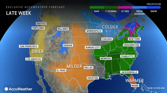
During the latter half of the week, the pronounced northward bulge in the jet stream is expected to level out, which will cause the warmth to gradually recede across the South Central states. Many locations will have temperatures trending back down 10-20 degrees lower than midweek values.
However, the mild conditions will continue to grip areas farther south in Texas, slightly longer than from northern Texas into Oklahoma. Highs in the upper 70s and 80s will persist into late week for locations like Houston and Brownsville.
Temperatures may rise slightly again across the Central states over the weekend as another zone of high pressure anchors over the region, but highs may only rise by a few degrees.
AccuWeather long-range forecasters say the prolonged warmth may help to fuel severe thunderstorms and a possible outbreak across part of the Central states next week.
Want next-level safety, ad-free? Unlock advanced, hyperlocal severe weather alerts when you subscribe to Premium+ on the AccuWeather app. AccuWeather Alerts™ are prompted by our expert meteorologists who monitor and analyze dangerous weather risks 24/7 to keep you and your family safer.
