
 Yahoo News
 UK weather update: Brits to experience near 30C heat as summer warmth arrives
Brits could be basking in a heatwave this month, with one forecast predicting temperatures nearing a sizzling 30C.
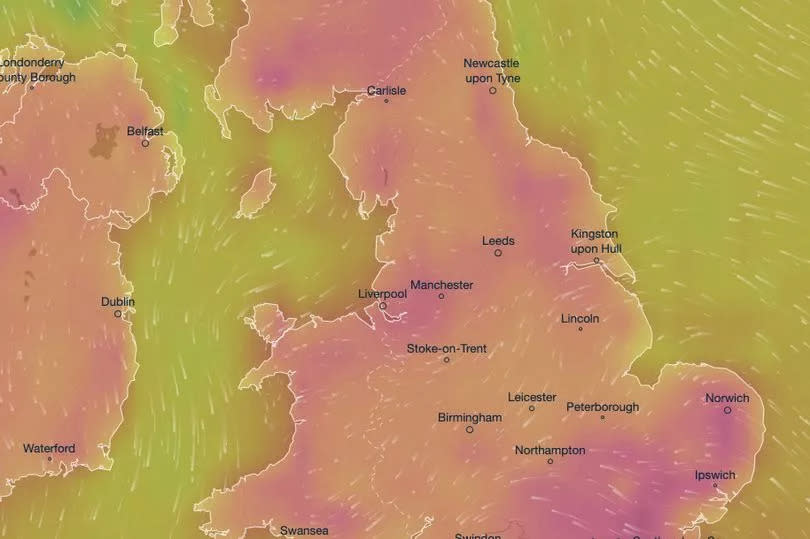
According to the meteorological website Ventusky, it will "feel like" a scorching 30C in the south of England on June 27. The village of Pitney in Somerset, near the town of Langport, is expected to feel the brunt of the heatwave.
Actual temperatures will be slightly lower, hovering just under 30C in some areas, including a predicted 28.8C in Salisbury.
READ MORE - Lip reader confirms Kate Middleton's regal words to George, Charlotte and Louis
READ MORE - New suspect in Scotland's infamous Bible John murder case identified through DNA
The hot weather, where temperatures are all slightly below 30C, will span across south and western Wales, the West Midlands and the northwest around 4pm.
Even as far north as Inverurie in Scotland may see temperatures over 26C, according to the forecast. Cooler temperatures are expected either side of June 27, reports the Mirror.
This burst of summer warmth will be a welcome change for many Brits after a chilly start to June. BBC's chief weather presenter Simon King attributed the recent cold spell to low pressure moving across the mid-Atlantic Ocean, predicting that highs wouldn't exceed 10C to 13C in the north and east or 14C and 17C elsewhere.
He suggested that the shift to summer might not occur until the end of June, with signs indicating a possible buildup of high pressure above the UK in the coming weeks. However, Ventusky's predictions offer a more optimistic outlook for June 20-23, with temperatures in the UK exceeding 20C.
London is even predicted to enjoy temperatures over 23C on June 23.
The Met Office has issued a weather warning for thunderstorms that are set to sweep across the UK later today. According to Britain's national forecaster, showers and thunderstorms will become more widespread and continue into the evening.
While not all areas will experience thunderstorms, those that do will see slow-moving storms bringing lightning, hail and heavy rain.
"The heaviest showers and thunderstorms could produce as much as 20 mm of rain in less than an hour with one or two places seeing 30-40 mm in two-three hours," the statement reads.
Here's a list of all the areas affected by the Met Office thunderstorm warning:.
Central, Tayside and Fife: Clackmannanshire, Falkirk, Fife, Perth and Kinross, Stirling.
North East England: Darlington, Durham, Gateshead, Hartlepool, Middlesbrough, Newcastle upon Tyne, North Tyneside, Northumberland, Redcar and Cleveland, South Tyneside, Stockton-on-Tees, Sunderland.
North West England: Blackburn with Darwen, Blackpool, Cumbria, Greater Manchester, Lancashire.
SW Scotland, Lothian Borders: Dumfries and Galloway, East Lothian, Edinburgh, Midlothian Council, Scottish Borders, West Lothian.
Strathclyde: Argyll and Bute, East Ayrshire, East Dunbartonshire, East Renfrewshire, Glasgow, Inverclyde, North Ayrshire, North Lanarkshire, Renfrewshire, South Ayrshire, South Lanarkshire, West Dunbartonshire.
Yorkshire and Humber: East Riding of Yorkshire, Kingston upon Hull, North Yorkshire, West Yorkshire, York.

