
 Yahoo News
 Weather map shows exact date intense thunderstorms and downpours set to batter UK
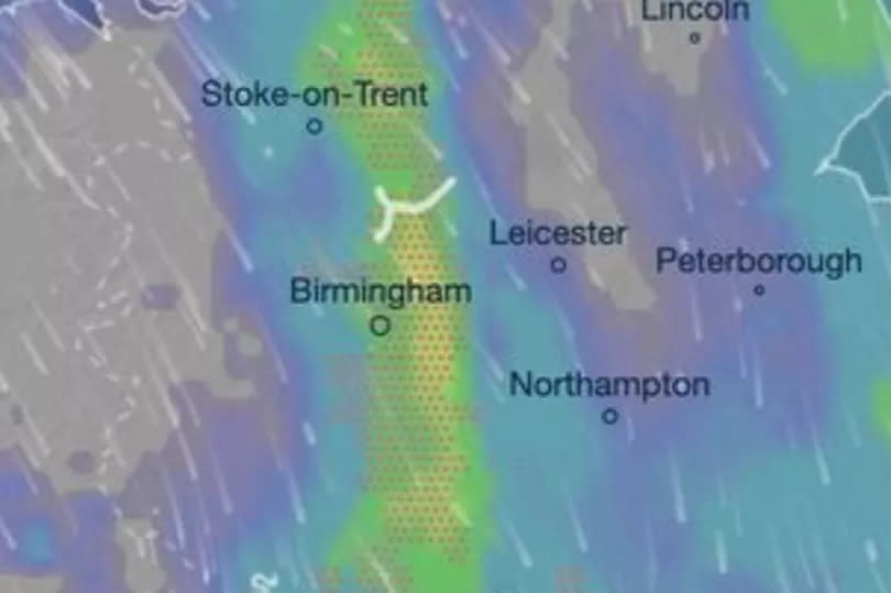
New weather maps show many parts of the UK will experience violent thunderstorms in the coming days. Monday will be the worst day, with thundershowers expected across the Midlands, parts of North Wales, and the Home Counties throughout the day.
The Mirror reports a band of low pressure will work its way south-east by 10am. It will then move across to the West Midlands by lunchtime tomorrow (June 10), forecasters at InMeteo say.
An interactive map created by them on Ventusky shows most of the UK will see rain by the afternoon. Despite the gloomy forecasts, thunderstorms will not affect people everywhere.
READ MORE: Coventry girl who suffered from anxiety and OCD says 'anything is possible'
READ MORE: Join the free CoventryLive WhatsApp community
But the thunder is far from the only bad weather Brits are set to face in the next few days. Stormy conditions are expected to advance toward the Atlantic Ocean on the morning of June 19.
They are expected to carry along the unusual meteorological event of 'freezing rain'. If predictions are correct, the incoming deluge could hit the UK on Thursday, June 20, with the storm making landfall near Glasgow around 4am that day.
Weather maps show it could be Liverpool that receives the heaviest volume of rain, especially at around 4pm. It is predicted the storm will move southeast across the UK, reaching London and Kent by about 7pm, BirminghamLive reports.
On the other hand, the long-term picture looks better, as new heat maps reveal 25C temperatures as Britain awaits a "super heatwave" this month. The Met Office's long-range forecast spans from Thursday June 13 to Saturday June 22.
It predicts: "After a dry start for many on Thursday, a band of rain is expected to push eastwards to affect much of the country. It will feel cool and damp for many, especially across hills in southern and central areas.
"On Friday and over the weekend, the weather will likely become a mix of sunshine and showers. During the daytime on each day, showers could become heavy and slow-moving, and there is a chance these might turn thundery at times. However, not everywhere will catch a shower, and many places may hold on to warm, sunny days with light winds. Next week, confidence for dominant weather regimes is low. There are tentative signs of building high pressure from the west, but rain and showers are still possible."
For Coventry, today will become increasingly cloudy, with some outbreaks of light rain arriving from the northwest, with a maximum temperature of 13C. Tonight will be breezy and milder compared to Saturday night (June 8), with a minimum temperature of 6C.
Here is the Met Office outlook for Coventry over the next few days:
Monday:
Early cloud and rain soon clearing to leave a brighter day, with some sunny spells developing. However, there will also be some scattered showers in the afternoon. Breezy and cool. Maximum temperature 16 °C.
Outlook for Tuesday to Thursday:
Tuesday will see a mixture of sunny spells and scattered showers. Fewer showers Wednesday. Rain likely to spread eastwards Thursday. Staying on the cool side for the time of year.
Get daily headlines and breaking news emailed to you - it’s FREE

