
 Yahoo News
 Weather maps reveal when scorching '27C Iberian plume to bring three-day heatwave to UK'
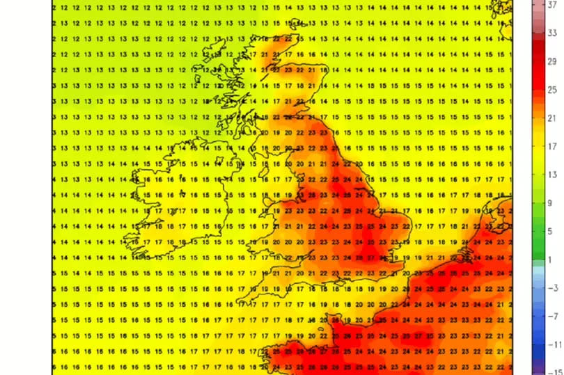
A three-day heatwave bringing scorching highs of 27C is heading for the UK. Weather maps reveal parts of Britain could be seeing sweltering heat as early as next week.
Data from Netweather indicates there could be highs of 27C near London on Sunday, June 23. The north of the country is also set to see some of the warm weather, with highs of 22C predicted for areas of Scotland.
Temperatures hovering around 25C are predicted for the North East - including near Newcastle, York and Harrogate. Temperatures will then dip slightly, turning to 24C the following day.
READ MORE: Strict new rules for passengers for major airlines after deadly plane incident
Sign up to the BirminghamLive newsletter here to get the latest updates on the biggest and breaking stories.
But that won't be the end of the sunny weather, with the three-day heat blast continuing into Tuesday, June 25. Jim Dale, senior meteorologist at British Weather Services, said warmer conditions are due to an airstream from Spain and France, Express reports.
He said: "If it comes off it looks like a short transfusion of very warm and somewhat humid weather, ahead of an approaching Atlantic frontal system. So, a southerly airstream c/o Spain and France.
"Expect widespread 20-22C, tops of 25-26C South East England and Moray Firth region." But Mr Dale warned any warm weather might not last long.
He added: "However, don’t hold your breath, it has yet to happen and if it does it’s unlikely to last." In its long-range forecast for Saturday, June 15 until Monday, June 24, the Met Office said temperatures are expected to be 'below average'.
It said: "During the first weekend of this period, a mixture of sunny spells and showers is likely across the majority of the UK. Some of the showers are expected to be heavy and could be accompanied by thunder.
"Temperatures will probably be slightly below normal for the time of year. Into the following week, similar conditions are most probable at first with further showers.
"Later in the week and through the weekend, confidence in the dominate type of weather pattern is low. As such, fairly typical conditions for the UK are most probable, with a mixture of weather types."
It added: "This means some spells of drier, sunny weather but also some showers or longer spells of rain at times. Temperatures will most likely be close to or slightly below average."

