
 Yahoo News
 Weather maps for Wales and the UK as temperatures set to reach 27°C
Temperatures are building across the UK towards the weekend with a short taste of summer for all. An area of high pressure over the UK is bringing dry and settled weather for most parts of the country.
BBC Wales weather presenter Derek Brockway says: "High pressure centred over the North Sea tomorrow (Saturday, May 11) will bring more fine settled weather and a taste of summer into the weekend."
Temperatures could peak around 27°C across parts of the UK this weekend, but there is a change on the way by Sunday. For the latest Welsh news delivered to your inbox sign up to our newsletter
READ MORE: Residents claim Roath Lake in Cardiff is becoming a 'fetid swamp'
READ MORE: You can see the Northern Lights in the UK this weekend
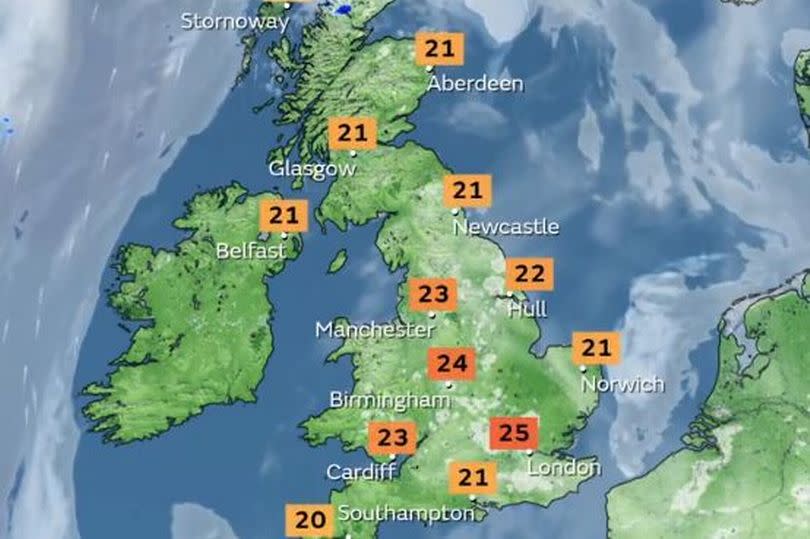
Temperatures peaked at 24.6°C in London’s St James’s Park on Thursday, making it the highest maximum temperature of the year so far. Cardiff was the warmest place in Wales yesterday recording 23°C.
These temperatures are likely to be surpassed over the next couple of days, with higher-than-average temperatures for many. Places in the southeast of England could see 26°C on Saturday and 27°C on Sunday.
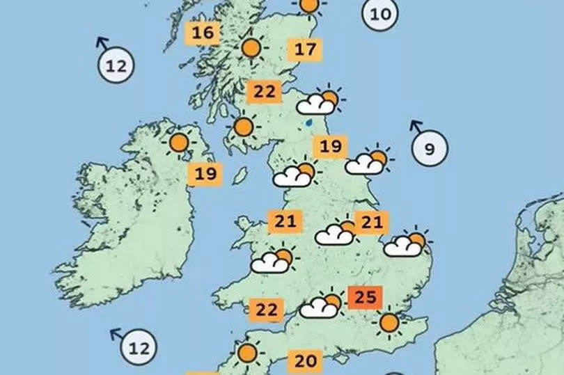
The Met Office says that most places will be fine and very warm on Saturday, with just a chance of a few heavy showers or isolated thunderstorms over the far north of England and Scotland in the afternoon, these most likely over higher ground.
Here are the weather maps for the weekend:
UK weather map for Friday:
UK weather map for Saturday:
All change on Sunday:
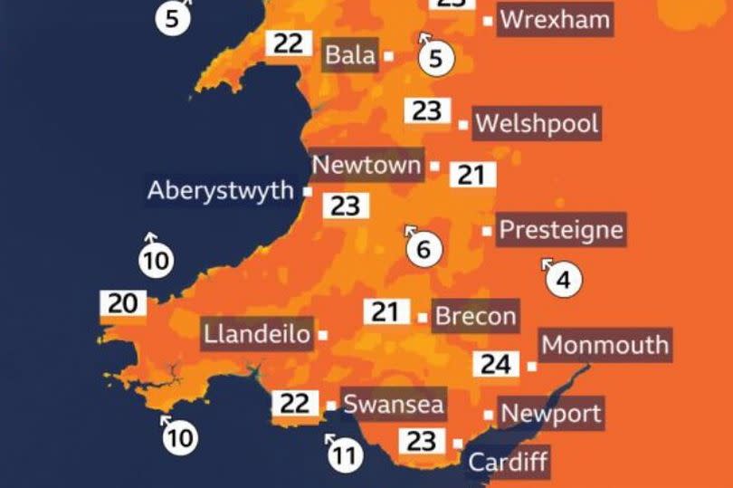
BBC Wales weather forecaster Derek Brockway says: "Cardiff was the warmest place in Wales on Thursday recording 23C. 24C in places today and tomorrow. Cirrus clouds making the sunshine hazy. Saturday the best day of the weekend for a trip to the seaside! Sunday will start dry but heavy showers and a risk of thunderstorms afternoon." A thunderstorm warning has been issued for the whole of Wales on Sunday, you can get more detail on that here.
The presenter shared maps of how Wales will look this weekend:
Friday

Saturday
The Met Office says that western parts will see cooler conditions on Sunday as showers arrive but parts of southeast England will remain warm. Temperatures return to close to average from Monday.
An area of low pressure moves into the southwest on Sunday bringing heavy showers and thunderstorms. It will be a fine start for many, although some mist and low cloud may affect some coastal areas in the northeast. Cloud will then increase from the southwest, bringing with it a change in conditions.
Met Office deputy chief meteorologist Dan Harris said: “Heavy showers and thunderstorms are likely to break out on Sunday morning, most likely across southwest England and Wales, but possibly also across western Northern Ireland too. They’ll track steadily north through the afternoon whilst probably growing into larger clumps of rain before clearing Scotland overnight.
“Some intense downpours are possible in a few places, giving up to 30mm in less than hour and perhaps 40-50mm over two to three hours. Hail, frequent lightning strikes and strong wind gusts will be additional localised hazards.”
Low pressure will be firmly in charge from the start of next week, bringing widely wet and unsettled conditions. Things will also turn cooler through Monday, with temperatures nearer average for much of next week.

