
 Yahoo News
 Atlantic tropical forecast into early July


Despite several factors working against robust tropical development over the next couple of weeks in the Atlantic Ocean, AccuWeather meteorologists say there is still a chance that one new storm could spin up close to home and perhaps another while approaching the Caribbean.
"A vast area of dry air, wind shear and an expanding shield of dust from the Sahara Desert in Africa will be the main deterrents for tropical development into the first part of July," AccuWeather Lead Tropical Meteorologist Alex DaSilva said.
 |
Dry air makes it hard for clouds to gather and evolve into thunderstorms. Strong, shifting breezes, known as wind shear, can prevent tropical storm formation. Additionally, when dust is significant it can dim and block the sun, reducing its warming effect on the atmosphere, further reducing the chances of tropical development.
"The historical average for named tropical systems through mid-July is only two, with the first during mid to late June," DaSilva said, "so historically you only get one more named system over the next two to three weeks, and we don't see much out there to differentiate against that at this time."
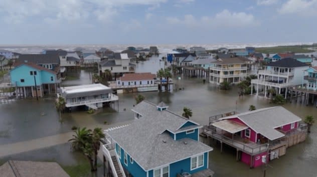
The first and only tropical storm, Alberto, formed on June 19 over the southwestern Gulf of Mexico and moved ashore in northeastern Mexico before dissipating well inland later on June 20. Alberto was responsible for flooding rain in northeastern Mexico and in parts of southern and eastern Texas with significant storm surge flooding as far north as the upper Texas coast.
 |
FREEPORT, TEXAS - JUNE 20: In an aerial view, housing complexes are surrounded by floodwater in a neighborhood on June 20, 2024, in Freeport, Texas. Storm Alberto, the first named tropical storm of the hurricane season, produced heavy winds and rainfall, creating flooding within various communities along Texas coastlines. (Footage by Brandon Bell/Getty Images) |
There were three other attempts at tropical storm development since Alberto, with the most significant being a tropical rainstorm that crossed the Florida Peninsula with torrential rain and flooding in mid-June. There was another system that tried to develop just off the coast of Georgia several days later, as well as a second system that crossed the southwestern Gulf and moved ashore in northeastern Mexico. That poorly organized system took a similar path to Alberto from a week or so earlier.
 |
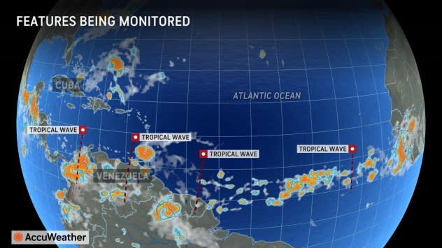
AccuWeather meteorologists are watching a tropical disturbance or wave of low pressure that will move from the central Caribbean and across part of Central America and southeastern Mexico in the coming days before emerging along the shoreline of the southwestern Gulf.
"This system is a bit farther south than Alberto and the second feature from a few days ago and since it will encounter much more land over a longer period of time, it likely has only a low chance of development spanning June 28-30," DaSilva said.
Thousands of miles farther to the east, tropical waves of low pressure will continue to roll westward from Africa in the coming weeks and on through the heart of the Atlantic hurricane season into the early autumn.
 |
At the end of June to early July, some information suggests one of those tropical waves may become a little more robust as it crosses the Caribbean, DaSilva said.
Before that, the system will have to fight on the edge of a harsh zone for tropical development, highlighted by dry air, dust, and wind shear over the eastern and central Atlantic. These conditions may prevail as it enters the Caribbean, further preventing development. It can only organize if the system remains to the south of the hostile zone. However, a more southern track could eventually result in significant land interaction with South America.
AccuWeather meteorologists believe that this system will find the "sweet spot" between the dry air and dust to the north and land to the south. Therefore, that tropical wave is now being given a high chance of development.
 |
AccuWeather meteorologists still anticipate a super-charged hurricane season for the Atlantic this year, with well above the historical average number of named systems and hurricanes. There is the likelihood of multiple rapidly developing systems near shore that could have some communities with little time to prepare and evacuate, if necessary.
Want next-level safety, ad-free? Unlock advanced, hyperlocal severe weather alerts when you subscribe to Premium+ on the AccuWeather app. AccuWeather Alerts™ are prompted by our expert meteorologists who monitor and analyze dangerous weather risks 24/7 to keep you and your family safer.
