
 Yahoo News
 Millions under heat alerts this weekend as record-breaking temperatures reach Mid-Atlantic, South
More than 120 million Americans remain under heat alerts this weekend as record-breaking temperatures reach the Mid-Atlantic and South.
The I-95 corridor between New York City and Virginia is scorching this weekend, with an Extreme Heat Risk for New York on Saturday and for the entire corridor on Sunday.
In New York City, the heat index could reach 103 degrees this weekend. A daily record high (tie) of 96 is possible Sunday.
MORE: Heat wave maps: How long the dangerous temperatures will last
The heat index could reach 102 degrees in Philadelphia on Saturday, and on Sunday up to 110. A daily record high of 98 is possible Sunday.
In Washington, D.C., the heat index is expected to reach between 105 and 110 degrees on Saturday, up to 104 on Sunday. Both Baltimore and D.C. will rival daily record highs both days this weekend with highs near 100 both days.
Much of this area is also under Air Quality Alerts because the stagnant air has led to low-level ozone concentrations which may be dangerous for sensitive groups.
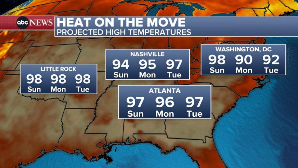
The most oppressive heat will be drifting deeper into the South in the coming days, providing some relief to portions of the Northeast.
Across the West, heat alerts are in effect across much of central and southern California, as well as parts of Utah, including Salt Lake City.
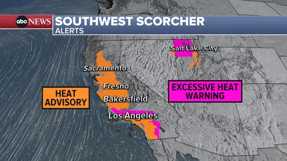
In the West, there will be daily record highs possible Saturday for Reno near 100. In Salt Lake City, the forecast is expected to reach around 100 on Sunday and there will be an Excessive Heat Warning in effect there as well.
In Palm Springs, temperatures may reach 114 degree Saturday through Thursday – prompting an Excessive Heat Warning.
On Saturday, temperatures in Redding and Sacramento may reach up to 107. Fresno may reach up to 108 both Saturday and Sunday. Heat Advisories are in place for all those locations through the California Valley.
MORE: Is air conditioning enough? Why extreme heat can still put you at risk
Severe storms bring flooding, wind damage
Storms have been firing up along the northern extent of this heat dome, sparking severe thunderstorms for several days from the Upper Midwest to the Northeast.
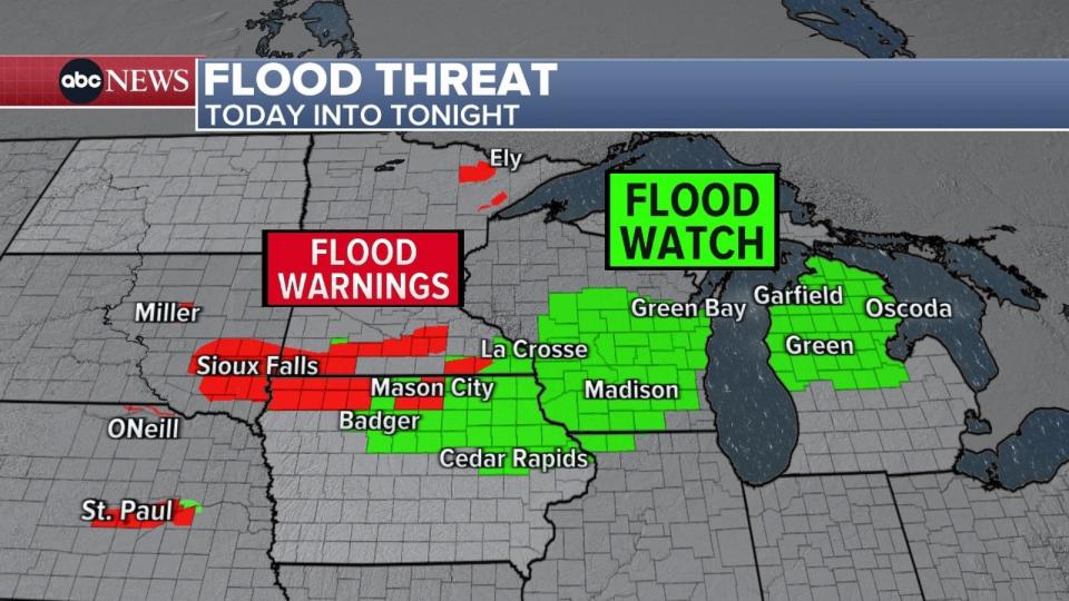
In northern Iowa, hours of heavy rainfall along a stalled front led to significant flooding issues as 4-8 inches of rain fell in less than 24 hours. Three-day rain totals have been in excess of 6 inches in parts of South Dakota, Nebraska, and Iowa. A narrow swath of 10-15 inches has been reported just south of Sioux Falls.
Numerous Flood Alerts remain in effect for this area with several rivers reaching major flood stage.
For the rest of Saturday and into tonight, the excessive rainfall threat drifts eastward into southern Wisconsin, where an additional 1-3 inches is in the forecast.
Severe storms are also likely in several locations Saturday. The Upper Midwest has a threat for damaging winds (along with the aforementioned flash flooding risk), which includes cities like Chicago, Milwaukee, and Des Moines.
In the Northeast, there is a risk for a few storms Saturday, but a more significant threat on Sunday. Across much of New England, there will be enough energy in the atmosphere to fire up storms that may contain damaging winds, small hail, and even a tornado or two.
Tropical update
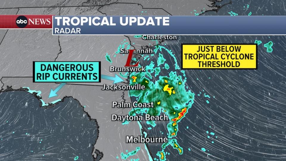
A relatively tiny storm off the coast of Georgia looked like it could become a named tropical system on Friday, but the storm didn’t get its act together in time. Regardless, the storm brought some rain to the Southeast, as well as a high surf and a rip current risk.
Elsewhere in the tropics, there is an area of interest around the Bay of Campeche in the southern Gulf of Mexico that has a 40% chance of forming into a named storm -- which would be Beryl.
This potential storm is not forecast to make landfall the United States, although there may be some minor impacts in the form of heavy rain in south Texas.
Millions under heat alerts this weekend as record-breaking temperatures reach Mid-Atlantic, South originally appeared on abcnews.go.com

