
 Yahoo News
 Exact date five areas of UK will be 'hotter than Majorca' as 24C heatwave hits
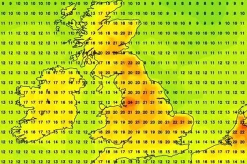
Five areas across the UK are expected to bask in temperatures hotter than Majorca this week, with a 24C heatwave forecasted to hit.
According to updated weather maps, Brits can expect to bid farewell to the dreary weather and welcome some Mediterranean warmth as the mercury is projected to climb past 20C. The wet weather that soaked a significant part of the country in recent days will soon become a distant memory.
Weather maps predict a massive rise in temperature up to 24C in just a matter of days. Numerous locations, including Manchester, Inverness, Fort William, Aberdeen and Edinburgh, will appreciate the much-anticipated sunshine with approximate temperatures of 18-20C, according to the maps from WX Charts.
READ MORE:
'I'm a GP - wear wrap sunglasses and quarantine teddies to survive pollen bomb'
Temperatures set to sizzle in May as Brits to bask in Bank Holiday heat
It's set to reach as high as 24C on May 3, outshining Menorca which is predicted only to reach 18C, reports the Mirror. For the period from May 2 to 11, the Met Office's forecast states: "In the first part of this period, many areas of the UK are expected to see periods of rain or showers.
"Some of these showers will be heavy and thundery, with the greatest chance of thunderstorms in the southeast. Along with this will be a fair amount of low cloud in the east at times, with spells of coastal fog, but also temperatures generally above average for the time of year.
"Overall, northwestern parts of the UK are likely to be driest and sunniest. Through the second week, temperatures will return closer to normal, perhaps dipping back below average, but it will also tend to turn gradually drier and more settled, with changeable conditions most likely to hang on longest in the south and southeast."
Latest 5-day Met Office forecast for the region
Monday:
Often wet across Cumbria today with persistent and heavy periods of rain over the Fells. Otherwise largely dry at first but scattered showers breaking out. Brisk southerly winds, strong on coasts, but nonetheless feeling somewhat warmer than over the weekend. Maximum temperature 14C.
Tonight:
Further showery rain this evening but turning drier overnight, although the odd shower remains possible. Winds easing a little overnight. Minimum temperature 7C.
Tuesday:
Rather cloudy at first but brightening up with sunny periods. Perhaps remaining cloudier on western coasts. Breezy but feeling warm in any sunshine. Maximum temperature 17C.
Outlook for Wednesday to Friday:
Turning drier as we move into May but showers remain possible. Feeling warmer than of late with spells of sunshine. Temperatures often somewhat above average but also breezy at times.

