
 Yahoo News
 Flooded Midwest to receive little respite from heavy rain, severe weather

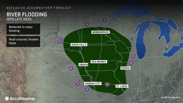
AccuWeather meteorologists expect powerful thunderstorms to keep rolling through the Midwest into the end of the month, offering little relief amid a historic river flooding event.
"So much rain has fallen in a zone from southern Minnesota and southwestern Wisconsin to northeastern Nebraska, including Iowa and southeastern South Dakota, that nearly a dozen major rivers are on the rampage," AccuWeather Senior Meteorologist Alex Sosnowski said.
AccuWeather meteorologist and social media producer Jesse Ferrell said 16 NOAA river gauges have already broken their all-time records, some by as many as 7 feet.
Major flooding is ongoing or will commence on the Big Sioux, Little Sioux, Des Moines, West Fork Des Moines, Vermillion, Cannon, James, Rock, Cedar, and Minnesota rivers, with several stations setting new record high water levels. Major flooding will occur on the Mississippi River at St. Paul, Minnesota, this week.
 |
"Many stations along the Missouri and Mississippi rivers are projected to peak above flood stage through the week as the surge of water flows downstream," Sosnowski said, "It may take several weeks for the surge of water to cycle through the middle portion of the Mississippi River."
Government officials in Iowa are seeking an expedited presidential disaster declaration due to the severity of the flooding. In southern Minnesota near Mankato, the Rapidan Dam on the Blue Earth River was near imminent failure Monday due to a collection of debris amid the flooding, according to KCRG-TV. Surging water had heavily eroded and damaged the side discharge channel.
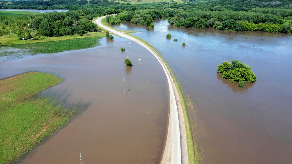
Travel and shipping operations can be impacted for weeks, and road closures and rail disruptions are likely to be inevitable. A train bridge that runs over the Big Sioux River in North Sioux City, South Dakota, experienced a partial collapse Sunday night as the river raged underneath.
The river flooding event was set in motion by a pattern that began during the middle of June, which triggered rounds of thunderstorms that unloaded a month's worth of rain in a matter of days in some areas, along with damaging winds, hail and even tornadoes. AccuWeather's expert team was sounding the alarm on this type of pattern to set up as early as the first week of June.
Sioux Falls, South Dakota, received 6.33 inches of rain in 72 hours from June 20-22, with 10.8 inches of rain so far in June. This puts June 2024 as the city's second-wettest month on record. The wettest June was in 2014, with 13.70 inches. The historical average rainfall for all of June in the southeastern South Dakota city is 4.23 inches.
Minneapolis is another city running well above historical average precipitation for the month, recording 6.14 inches as of June 25, compared to the monthly norm of 4.58 inches. Some nearby cities have been spared, however, due to the hit-or-miss nature of the thunderstorm complexes. Des Moines, Iowa, for example, has only received 54% of the historical average rain for June of 5.26 inches.
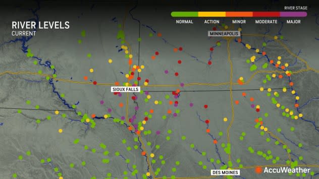
 |
River stages on the afternoon of June 25, 2025. |
Flooding of agricultural areas may last for weeks, as the vast areas of flat terrain in the region make it difficult for water to recede and the ground to dry out. Making matters worse will be additional opportunities for rainfall into the end of the month, AccuWeather meteorologists warn.
"With an area of high pressure positioned over the interior Southwest or southern Plains, there will be an increased threat of thunderstorm complexes, including potential derechos, from the north-central Plains and Midwest to the Great Lakes and Ohio Valley into early July," AccuWeather Lead Long-Range Meteorologist Paul Pastelok said.
A long-lived complex of thunderstorms advanced from Iowa, Wisconsin and northern Michigan from Monday night to northern Illinois, northern Indiana and southern Michigan Tuesday morning. The storms prompted ground stops at the airports in Chicago as they approached during morning rush hour.
The storms continued to pack damaging winds, large hail and torrential downpours as they advanced to the south and east into Tuesday night. A wind gust of 90 mph was recorded at the airport in Omaha, Nebraska.
Most of the northern Plains and Upper Midwest will catch a needed break from heavy rain and powerful thunderstorms Wednesday as these dangers shift to the south and east.
 |
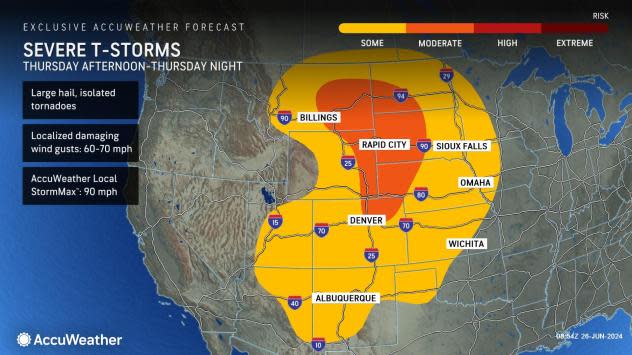
A severe weather risk will return to the northern and central High Plains later Thursday as a storm rolls through the interior Northwest and across the Rockies. This storm will help to enhance showers and thunderstorms in the Southwest.
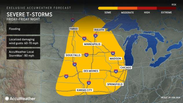
Wind gusts could be destructive with an AccuWeather Local StormMax™ of 90 mph, which has a higher likelihood of occurring east of the Rockies and in the northern and central High Plains. Large hail and isolated tornadoes can also occur.
By the end of the week, one or more clusters of thunderstorms with flooding downpours, high winds and hail may cross the North Central states as this system moves eastward.
 |
Residents may get a reprieve from stormy weather for a day or two over the weekend before the atmosphere reloads at the beginning of July and ignites additional rounds of heavy, potentially damaging thunderstorms.
Want next-level safety, ad-free? Unlock advanced, hyperlocal severe weather alerts when you subscribe to Premium+ on the AccuWeather app. AccuWeather Alerts™ are prompted by our expert meteorologists who monitor and analyze dangerous weather risks 24/7 to keep you and your family safer.
