
 Yahoo News
 Health Heat warning over Kent weather as 'highest temperatures so far this year' predicted
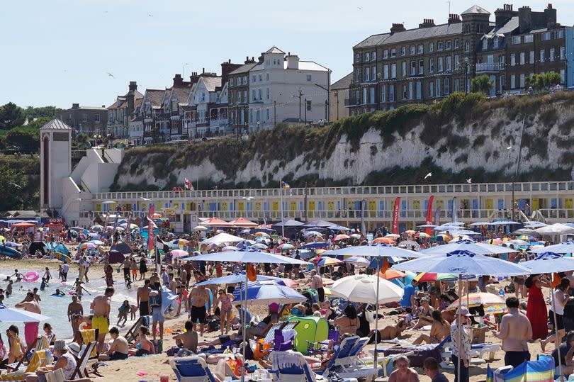
As temperatures are expected to rise to 25C and over in Kent across the coming days, a new yellow heat health alert has been issued. The UK Health Security Agency’s (UKHSA) warning covers the entirety of the south east region, with yellow alerts also in place for the south west, London, the east, the west midlands, the east midlands, the north west, and Yorkshire and The Humber.
Current Met Office forecasts predict highs of up to 27C in the region over the coming days. This prolonged spell of hot weather is expected to begin in Kent from Sunday afternoon (June 23), with peak temperatures sitting comfortably around the mid 20s each day up to and including Thursday.
Liam Esslick, a meteorologist at the Met Office, said: “According to the latest models, there is a chance temperatures could reach 30C. It’s not guaranteed but this will likely be towards the south-east of England, particularly London, Essex and Kent.
“My advice to people would be by all means go out and enjoy. They have been waiting for summer. But UV levels are going to be high and the sun will be very intense. Wear protection like sun cream, stay hydrated and try to get some shade in the midday sun. People sensitive to the sun should take particular precautions.”
Read more: Description of 'key witness' Kent Police are searching for after woman assaulted
Read more: Urgent recall over meat products from Kent supplier
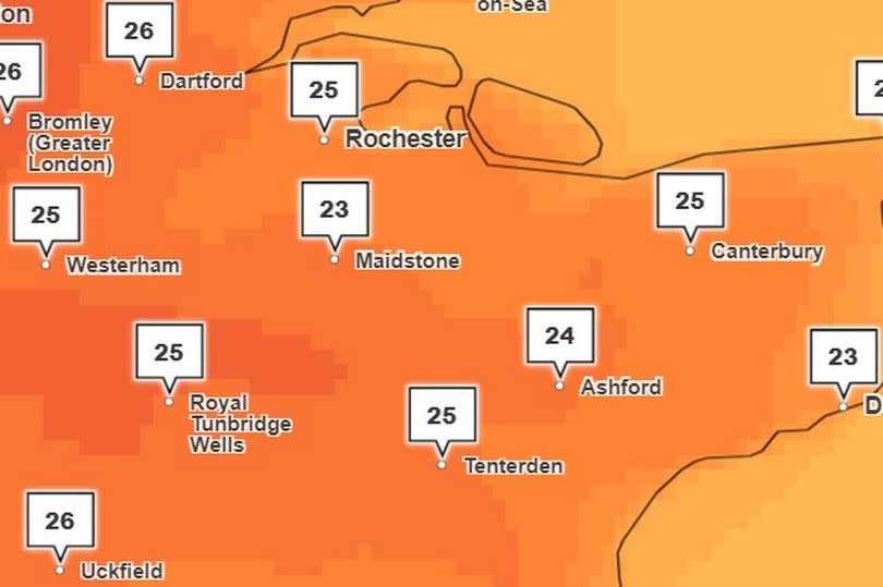
Areas to the north of Kent are likely to feel the hottest temperatures , with Dartford, Gravesend, Medway and Maidstone set for peaks of 26C and 27C throughout the week.
As the hot weather looms, the UKHSA has warned that “there is potential for significant impacts to be observed across the health and social care sector due to the high temperatures” here in the south east. This includes increased mortality, particularly in those aged 65 and over, as well as in younger age groups.
There is likely to be an increased demand for remote care services and rising temperatures in internal care settings, such as hospitals and care homes. The hot weather may also impact the ability of services due to the effects on the workforce as indoor environments are likely to overheat.
The Met Office defines a heatwave as when a location records a period for at least three consecutive days with daily maximum temperatures meeting or exceeding the heatwave temperature threshold. The threshold varies by UK county, ranging between 25C and 28C in areas in England and Wales.
Forecasters from the Met Office currently predict a return to more average temperatures toward the end of next week. The long range forecast for Wednesday, June 26 to Friday July 5 adds: “This transition brings with it the risk of some showers or longer periods of rain from as early as next Wednesday, and potentially some thunderstorms too, particularly in the south but with many areas at risk.”
Weather forecast for the South East
This weekend
On Saturday, dull with extensive low cloud, and patchy light rain, at first. As sunny intervals eventually break though so isolated sharp showers may develop for a time, before dying away to leave warm sunny spells by evening. Light sea-breezes develop. Maximum temperature 24 °C. Into tonight, l argely sunny through the evening and then mostly clear overnight, with very light winds. Isolated mist and fog patches may form, especially in rural locations. Minimum temperature 8 °C.
On Sunday, a sunny start but then areas of low cloud are likely to gradually spread east, although still bright or sunny spells will occur. Feeling very warm, with light sea-breezes developing. Maximum temperature 26 °C.
Outlook for Monday to Wednesday:
Becoming hot and humid, although through Wednesday there is a chance of heavy showers or thunderstorms developing. There will be varying amounts of cloud, but also bright or sunny spells.
“Confidence in the forecast reduces markedly from Wednesday onwards" Dan Rudman, Met Office Deputy Chief Meteorologist. said. He added: "There is uncertainty in both how long the heat will last and how it will break down, which we will be keeping an eye on for the coming days. However, by next weekend, cooler, changeable conditions become more likely.
"The best advice for anyone wanting to know how the weather is shaping up from mid-next week, is to keep an eye on our latest forecast."
Get more news from KentLive straight to your inbox for free HERE.

