
 Yahoo News
 Met Office verdict as North American blast to push UK mercury to 25C
The UK could see 'very warm' sunshine in just hours. The Met Office has issued details about a change in the mercury heading our way.
The sudden rise in temperatures for much of Britain is due to a strengthening jet stream spiked by contrasts in North America. A 'ridge of high pressure' will sweep across the UK and will be driven across the country by the jet.
Conditions are expected to turn 'more settled for most' on Wednesday. But not every part of the country will see the sunshine, as outbreaks of rain from the Atlantic could hit later this week.
READ MORE: Maps show when and where 'pollen bomb' will sweep UK as warnings issued to hay fever sufferers
Don't miss the biggest and breaking stories by signing up to the BirminghamLive newsletter here.
The Met Office said: "There is even a small risk of heavy rain and thunderstorms briefly affecting the south before these arrive. The westerly wind will bring temperatures back up to average quite widely, and becoming above average in sunnier periods mid-week."
Met Office deputy chief meteorologist Dan Harris said: "In stark contrast to the first half of June, where temperatures have widely been below average, we are expecting to see a steady uptick through the second half of this week, rising to around or above average, and it will likely feel very warm for those in the sunshine. This initial spell of warm conditions isn’t expected to last too long however, as it turns more changeable through Friday and into the weekend with areas of cloud and rain spilling east across the UK."
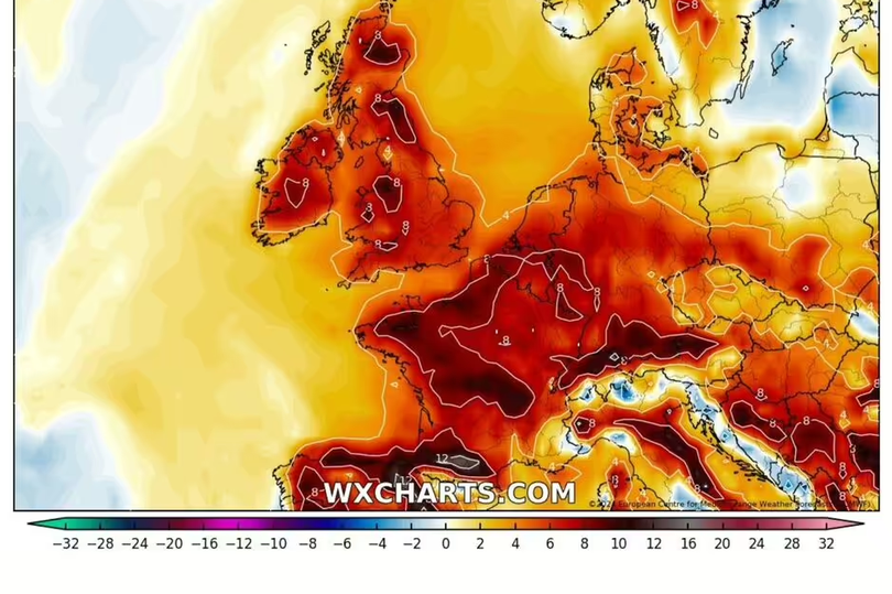
Temperatures this week are likely peak at around 24C or 25C on Thursday and Friday in the south of the country, Express reports. Weather maps from WXCharts indicate it will get warmer towards the end of the week.
This coming weekend is set to return to largely cloudy conditions for many. The Met Office added: "The weekend’s weather is expected to start with largely cloudy conditions, and possibly turning breezier too.
"Any rain or showers remain more likely in the north and west, with generally drier conditions further south and east." But it says a gradual trend towards more settled, and warmer weather is then likely into next week, with a small chance that this could persist for 'several days'.
Its added: "This may lead to a spell of hot weather with winds from the south or southeast. There are a number of other possible scenarios at this range, with details likely to become clearer through this week as we get nearer the event."

