
 Yahoo News
 UK weather: Bermuda storm to hit Britain in days as weather maps turn blue
A monstrous storm from Bermuda is set to batter the UK with mega winds of up to 55mph, abruptly ending the short-lived fine weather. Weather maps have turned a disappointing shade of blue as they signal the incoming storm which is set to mark an end to the current warm weather.
Brits will be soaking up the sun this weekend, with temperatures soaring to a sizzling 26C in some areas on Saturday, potentially marking it as the hottest day of the year so far. However, meteorologists are forecasting a dramatic shift back to "unsettled" conditions next week. Radar images reveal a formidable thunderstorm brewing over the Atlantic, heading straight for us, reports the Mirror.
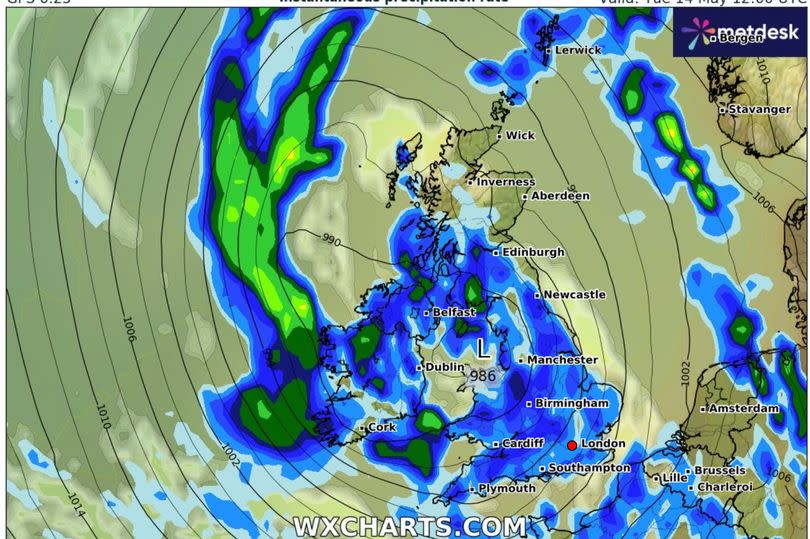
According to WXCharts, a weather front laden with heavy rain is forming in the mid-Atlantic and is expected to sweep across to the British Isles early next week. The worst of the storm is predicted to hit on Tuesday, May 14, drenching the country with persistent rain, particularly along the western coast where rainfall could reach 2-3mm per hour, accompanied by fierce wind gusts of up to 55mph.
Read more:
Symptoms of 100-day whooping cough and how to prevent it as five babies die and cases rocket
BBC Garden Rescue's Lee Burkhill inundated with support after 'horrendous start to year'
The Met Office has echoed these sentiments, anticipating a change in the weather from Sunday due to a developing low-pressure system from the Atlantic. Deputy Chief Meteorologist Tony Wisson commented: "Many places will start fine and warm on Sunday, though it is likely to become cloudier from the west or southwest during the day. This will be accompanied by scattered showers, which could be heavy with thunder.
"On Monday we're likely to see more widespread and longer-lived spells of rain, some of which will be heavy and thundery. This will also lead to a much cooler feel to the day."
Meanwhile, Brits are being advised to stock up on suncream as UV levels are predicted to soar over the weekend. From Friday through Sunday, forecasters predict a UV level of 6 in London and the south of England, considered "high exposure".
Moderate exposure is expected in northern England, Scotland, Wales and Northern Ireland. The Met Office took to X (formerly Twitter) to advise the public to "make sure you stay protected whilst out enjoying the sun", with hayfever sufferers also warned to brace themselves for increased pollen levels.

