
 Yahoo News
 Flood-hit towns brace for more rain as Storm Jorge continues
Flood-hit towns are bracing for further downpours as Storm Jorge pushes Britain into the wettest February on record.
February’s third named storm is bringing rain, gales and snow, prompting weather warnings stretching from Cornwall to the north of Scotland and across to Northern Ireland.
Pontypridd, which was also flooded two weeks ago, and the Ely area of Cardiff are among the worst affected areas. Residents have been advised to stay indoors to avoid winds of up to 70mph and have been warned that water levels could rise further.
Related: UK weather: third storm in a month to bring more misery in flooded areas
In Ireland, a lorry was overturned as winds battered the N59 road in Galway. The driver sustained no injuries, gardaí said.
Gardaí are at the scene of an overturned truck in the Maam Cross area of Galway. Luckily the driver of the truck sustained no injuries.
An Garda Siochana are advising that people adhere to the weather warnings in place and ask that people do not make unnecessary journeys. pic.twitter.com/zKUDrrnPHj— An Garda Síochána (@GardaTraffic) February 29, 2020
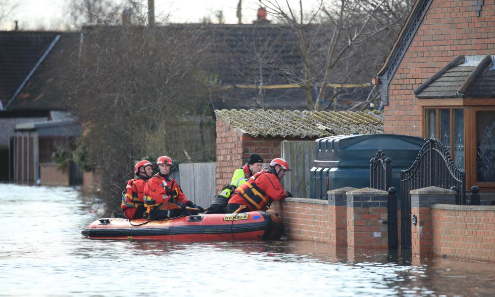
Police declared a critical incident in flood-hit south Wales overnight, as Storm Jorge brought heavy rain and strong winds in what is Britain’s fourth weekend of downpours.
Cardiff council said its road team has answered about 100 incidents. It has deployed emergency teams to work throughout the night on flood defences and removing debris.
More than 600 homes and a similar number of businesses have been hit in Wales, making up around a quarter of affected properties in the UK.
South Wales police said emergency services, local authorities and other organisations were working continuously to ensure the safety and welfare of those affected, minimise damage to infrastructure and property, and minimise disruption.
Supt Andy Kingdom said: “Indications are that the rain is set to stop and river levels will soon recede. There is still significant surface water and debris on the roads throughout the force area so we would advise people only to travel if absolutely necessary.”
In Shropshire, the Environment agency repaired flood defences along the River Severn at Ironbridge and Beales Corner.
The Met Office has declared this month as the wettest February since records began in 1862 – with a UK average of 202.1mm, beating the February 1990 figure of 193.4mm.
There were six yellow weather warnings for rain, wind and snow in force across the country on Saturday morning.
Out and about early on Saturday?
Heavy #rain will clear to the east with showers following on. Watch out for #ice in Northern Ireland#StormJorge pic.twitter.com/JBUUPXDiNr— Met Office (@metoffice) February 28, 2020
The rain warning was lifted before midday as showers eased but alerts remained in place for gales and the potential for power cuts, transport delays and large waves for coastal communities.
The wind warnings last until 9am on Sunday across much of England and Wales and until 3pm the same day across Northern Ireland, southern Scotland, and northern England.
Persistent snowfall was forecast over higher parts of Scotland, with up to 30cm predicted in some places, with warnings in place until noon on Monday, the Met Office said.
A total of 83 flood warnings were in place across England and Wales, mostly in the south-west, along the English-Welsh border, and in Yorkshire. A further 211 “flooding is possible” alerts are also in force.
The wind-chill factor will make temperatures feel close to freezing, said the Met Office.
Heavy rain, which started with Storm Ciara and continued with Storm Dennis, contributed to record river levels as safety teams put in “Herculean efforts” to erect flood defences.
Towns including Ironbridge and Bewdley along the Severn, and East Cowick in east Yorkshire, along the River Aire, are among the worst-hit areas in England.
The Environment Agency said 1,000 staff per day had worked on flood defences and pumps, clearing debris and repairing damaged defences, erecting 3.7 miles of barriers. It said the country needed to brace itself for “more frequent periods of extreme weather like this” because of the climate emergency.

