
 Yahoo News
 Exact time thunderstorms are set to strike Devon today
Devon has been warned to brace for 'likely' thunderstorms in a severe weather alert from the Met Office. Parts of region, particularly towns in South Devon should expect heavy showers and storms throughout the afternoon today (Tuesday, May 21) and possibly tomorrow (May 22).
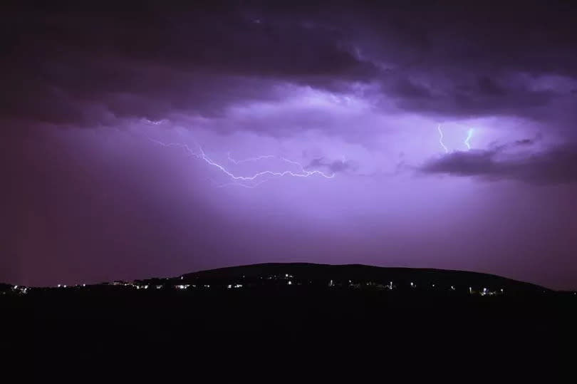
Hail and lightning strikes are possible across the region and forecasters warn of difficult driving conditions, with a chance of power cuts and flash floods. The warning has been issued for 12pm -9pm today and is active across Devon, Cornwall, Somerset and Dorset.
According to current predictions, rain is expected to move in between 11am and 12am. These are expected to be patchy but very heavy and meteorologists say up to 50mm of rain could fall in just a few hours across the region. Lightning strikes and hailstorms are also possible.
Read more:
The Met Office said: "Heavy showers and thunderstorms are expected to develop during the afternoon across parts of southwest England before slowly dying out during the evening. Many places will miss the worst, but where they do develop, some slow-moving and intense downpours are possible, giving accumulations of 20-30 mm in around 1 hour, and a lower likelihood of 40-50 mm in 2-3 hours in a few locations. Frequent lightning strikes and hail are also possible."
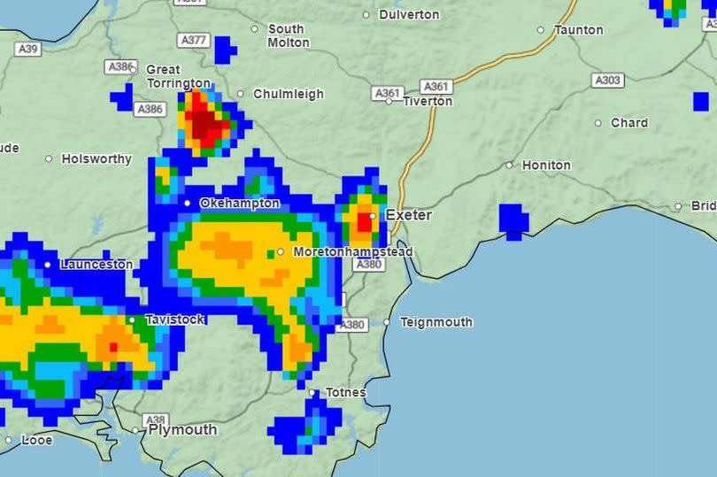
For Devon, the worst of the weather is expected to fall between midday and 9pm. As the day progresses, the storms will move vaguely eastwards before moving into Somerset and up towards Bristol.
Hour-by-hour thunderstorm forecast
11am - Small showers start to appear across Devon and Cornwall. Bright sunshine for most, with temperatures around 17C.
12pm - Rain picks up across Dartmoor, Barnstaple and parts of Cornwall. Some hail in North Devon. Temperatures between 16C and 19C.
1pm - Thunderstorms predicted in Moretonampstead and Tavistock with heavy rain for towns in North Devon and Dartmoor. Showers moving eastwards, but still focused on Dartmoor and South Devon.
2pm - Thunderstorms in Totnes and on the Devon-Cornwall border. Very heavy rain across the moors and Torbay.
3pm - Storms in Moretonhampstead, Chulmleigh and Exeter. Very heavy rain expected in all of these areas, with temperatures starting to drop.
4pm - Thunderstorms expected in Okehampton and parts of Dartmoor. Heavy rain persists but continues to move eastwards towards Tiverton and Somerset.
5pm - Thunderstorms ease off in Devon, though rain is still expected. Heaviest downpours move towards Honiton and Dorse.
6pm - Some showers remain across the moors and parts of East and Mid-Devon. Sunshine returns for most.
Met Office South West forecast
Today
Early low cloud clearing through the morning to leave sunny spells with scattered showers developing into the afternoon, these turning heavy or thundery especially across parts of Devon and Cornwall. Maximum temperature 20 °C.
Tonight
Showers will ease during the evening, with most places becoming dry with clear spells overnight. Some low level cloud developing across parts of Devon and Cornwall later. Minimum temperature 8 °C.
Wednesday
A dry and bright start with any low level cloud soon to break up and clear. Showers once again developing but are expected to be less heavy than today. Maximum temperature 19 °C.
Outlook for Thursday to Saturday
Largely dry and fine on Thursday and Friday with just the odd shower around. Saturday likely to start dry but showery rain is expected to arrive later in the day.

