
 Yahoo News
 Horror thunderstorm to unleash 10 days worth of rain in just three hours
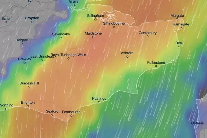
A massive thunderstorm is set to dump 10 days worth of rain on parts of the UK in just three hours.
A third of June's entire rainfall average is forecasted to drench southern areas of the country soon. Kent is bracing for a deluge with 15mm of rain expected over three hours during an imminent storm.
Weather maps from Ventusky predict that Brighton, Southend-on-Sea and Ipswich will also be engulfed by stormy conditions this week. The Met Office has also confirmed the likelihood of 'heavy, thundery rain' sweeping across the country during a period when temperatures are typically expected to reach highs of 21C.
READ MORE:
Heatwave alert as Iberian plume to push UK temperatures past 25C within days
Met Office has some bad news for anyone hoping for a barbecue with 'worst June since 2020'
Its longer-term forecast read: "Following a couple of days of largely fine and settled weather, a gradual transition to more changeable conditions from the Atlantic is likely to take place with periods of cloud, rain and stronger winds most often affecting the west and northwest. There remains a small chance of an area of heavy, thundery rain affecting parts of the south on Friday, June 21, possibly accompanied by briefly hot and humid conditions."
July may also see spells of rain, Mirror reports. A forecast for the first two weeks of July read: "All areas can expect to see some spells of drier, sunnier weather, but there will also be showers or longer spells of rain at times."
However, the Met Office suggests temperatures would be about average in the latter half of July.
It said: "Temperatures are most likely to be close to or slightly above climatological average."
The Met Office's outlook for today (June 18) reads: "Showers developing through the morning, some of these could be heavy with the odd rumble of thunder. Bright and breezy at the coast, but warm in the sunshine out of the wind. Maximum temperature 18C."

