
 Yahoo News
 Russia’s war in Ukraine: complete guide in maps, video and pictures
Where is fighting happening and how did we get here?
What is happening?
Frontlines have shifted as Russia makes advances in the fiercely contested eastern Donbas region, and Ukraine’s forces waged a successful counteroffensive near the strategic Russian-held city of Izium.
Near the north-eastern city of Kharkiv, where Ukrainian forces have been on the attack since early this month, local commanders said they believed Russia was withdrawing troops to reinforce positions around Izium to the south.
Russia’s defence ministry claimed to have carried out “high-precision” missile strikes on four artillery munitions depots in the Donetsk area, also destroying two missile-launching systems and radar and taking out 15 Ukrainian drones.
But British military intelligence said in an update that Russia’s offensive in the Donbas had “lost momentum” and that it believed Moscow had now lost one-third of its invading force.
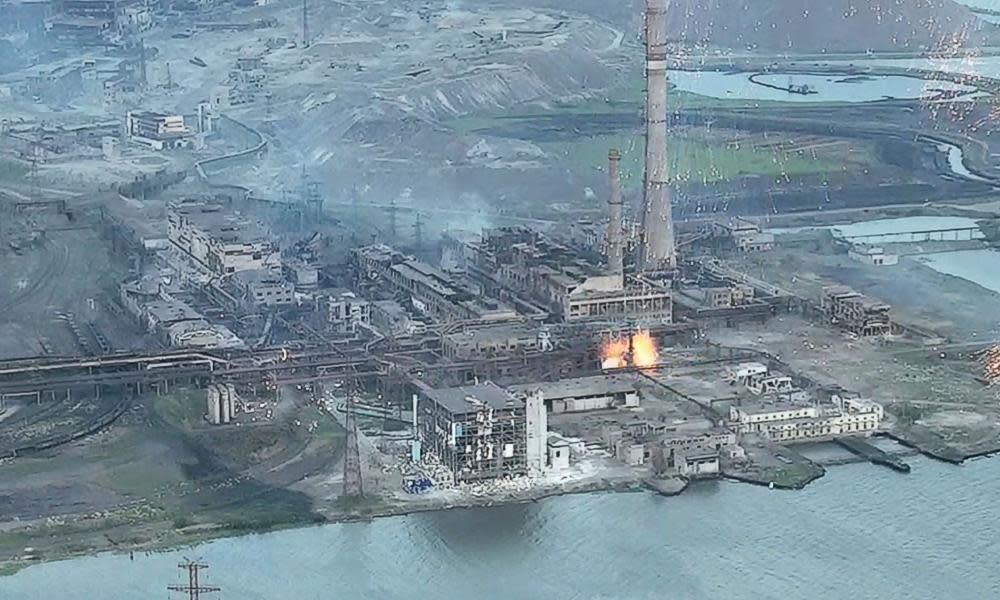
Heavy fighting is still raging at the besieged Azovstal steel plant in Mariupol, as Russian forces attempt to complete the capture of the strategically vital port.
A pro-Russian separatist commander posted a video on Sunday showing white brightly burning munitions falling on the steel plant. It was not immediately apparent what type of munitions were used or the time of the video, which was posted on the Telegram messaging application by Alexander Khodakovsky, a commander of the forces of the pro-Russian self-proclaimed republic of Donetsk.
Hundreds of Ukrainian soldiers are holed up in the steel mill’s underground bunkers, many of them wounded.
What happened in first three weeks of the invasion?
default
How did we get here?
In the months before its invasion, Russia deployed hundreds of tanks, self-propelled artillery and short-range ballistic missiles from as far away as Siberia to within striking range of Ukraine.
Moscow’s rhetoric grew more belligerent. Putin demanded legal guarantees that Ukraine would never join Nato or host its missile strike systems, concessions he was unlikely to receive. A flurry of diplomatic activity did little to ease tensions.
The second half of February was long considered the most likely period for a potential offensive. Russian soldiers stayed on in Belarus beyond the end of planned military exercises, and the Winter Olympics, hosted by Russia’s ally China, concluded.
The invasion was preceded on 22 February by Putin saying Russia would recognise the territorial claims of self-proclaimed republics in Luhansk and Donetsk. He had already ordered his forces into Russian-controlled territory in Ukraine.
What do we know about Russia’s deployments?
Scores of battalion tactical groups – the smallest operational unit in Russia’s army, consisting of about 800-1,000 troops – were put in place near the borders of Ukraine in Russia and Belarus before the invasion.
As of 18 February, the US estimated that Russia had 169,000-190,000 personnel in and around Ukraine.
An estimated 32,000 separatist forces were already operating in the breakaway areas in Donetsk and Luhansk – some of whom were likely to be unacknowledged Russian forces – before the invasion.
Many of the heavy weapons stationed near Ukraine arrived as far back as spring 2021. Over the new year Russia also began to move tanks, artillery, air-defence systems and fighter jets to Belarus for joint exercises in February. That deployment then grew.
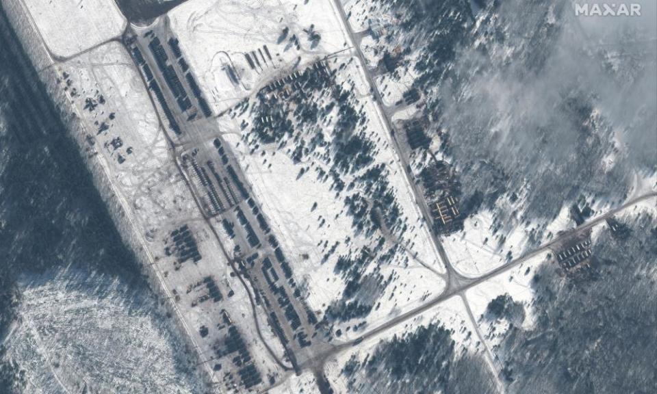
These satellite image composites show the buildup of troops in Yelnya and Pogonovo over the new year.
Satellite photographs also showed increased deployments in Novoozernoye, in western Crimea.
The US estimates that 10,000 troops moved into Crimea in late January and early February.
Satellite images taken on 20 February showed troops and equipment being moved from holding areas to potential launch locations.
How do the militaries compare?
Russia’s invasion pits the Kremlin’s large, recently modernised military against an adversary largely using older versions of the same or similar equipment, dating back to the Soviet era.
Russia has significant numerical advantages on land, and in particular in the air and at sea, although Ukrainians are defending their homeland.
What is the historical context?
In 2014 Putin sent troops to annex Crimea, a mainly Russian-speaking region of Ukraine. Russia also incited a separatist uprising in Ukraine’s south-east, clandestinely sending soldiers and weapons to provoke a conflict that grew into a full-blown war.
A 2015 peace deal established a line of demarcation and called on both sides to make concessions. After that, low-level fighting continued along the front, and each side accused the other of violating the agreement.
Going back further, Russia has long opposed any attempts by Ukraine to move towards the EU and Nato.
One of Putin’s oft-repeated demands was a guarantee that Ukraine would never join Nato, the alliance of 30 countries that has expanded eastwards since the end of the cold war.
What was the role of Nord Stream 2?
On 22 February, the German chancellor, Olaf Scholz, stopped the certification process for the Nord Stream 2 gas pipeline in response to Russia’s recognition of the two self-proclaimed republics.
First announced in 2015, the $11bn (£8.3bn) pipeline owned by Russia’s state-backed energy firm Gazprom was built to carry gas from western Siberia to Lubmin in Germany’s north-east, doubling the existing capacity of the Nord Stream 1 pipeline and keeping 26m German homes warm at an affordable price.
Nord Stream 2, Europe’s most divisive energy project, bypassed the traditional gas transit nation of Ukraine by running along the bed of the Baltic Sea.
It faced resistance within the EU, and from the US as well as Ukraine, on the grounds that it increased Europe’s energy dependence on Russia, denied Ukraine transit fees, and made it more vulnerable to Russian invasion.

