
 Yahoo News
 Weather maps show Britain to take unexpected turn after three days of heat
Britain is expected to endure a big 20C swing in temperatures in just three days as the volatile UK weather veers between extremes. To begin with, next Thursday and Friday (May 2 and 3) will be very warm - although there will be a cold period in the days before that.
Warmer temperatures are expected across northern regions on May 2, which is good news for Coventry. Temperatures are likely to increase to 16C on both days, with southern areas expected to enjoy warmer conditions as wind direction changes suddenly.
Metdesk's weather maps show Greater London, Hampshire and parts of Essex will see the best of the weather by the end of the week. However, after that, temperatures will tumble to below freezing on Monday, May 6, the next bank holiday.
Read more: New church hall where children can 'play safely' to be built in Coventry
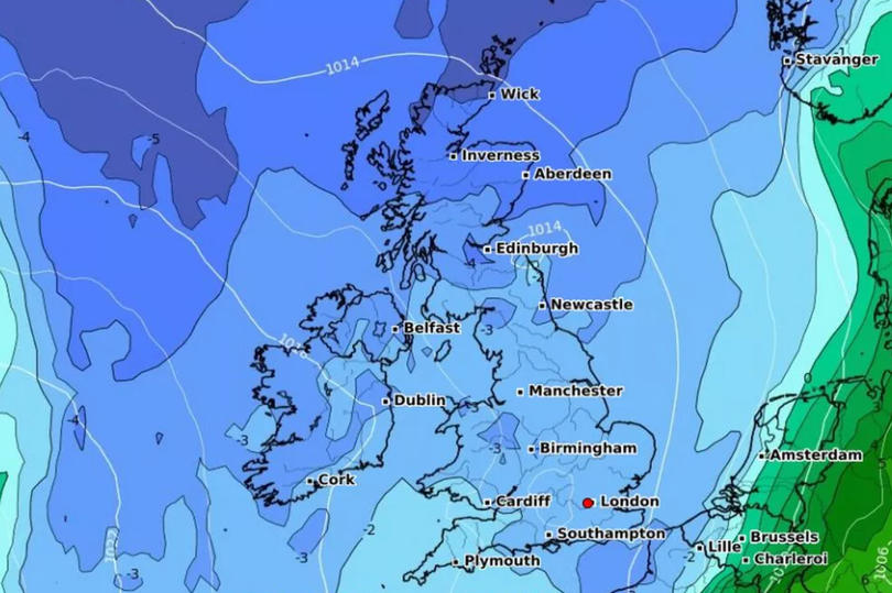
Metdesk's map for the bank holiday weekend shows a picture of blue, representing colder temperatures as the wind is likely to come from the North Sea. Many will wake up to temperatures below freezing, particularly across North Wales, Cumbria, parts of Northeast of England, and most of Scotland.
Metdesk says it will be as cold as -4C in and around Edinburgh, a huge 20C drop from the 16C highs in the south. Temperatures exceeded 16C on Wednesday (April 24) in Plymouth, but in Essex barely scraped 11C.
The Met Office added that the unsettled weather pattern is set to remain throughout May. For the week of Friday, May 10 to Friday, May 24, its website reads: "In this period, the chances of unsettled weather are slightly less than usual in the north and about the same as usual further south.
"Therefore, some spells of wetter weather are likely for all, but perhaps especially southern areas with the driest conditions probably further north. Temperatures are probably near average though with some cooler interludes possible. Also worth noting that average temperatures themselves rise by around 1C per week at this time of year."
For Coventry, today will have sunnier spells with the odd shower, but turning cloudier through the afternoon with a maximum temperature of 12C. Tonight will remain dry with shower outbreaks of rain arriving by dawn, with a minimum temperature of 4C.
The Met Office forecast for Coventry area
Saturday:
A cloudy start to the weekend with showery outbreaks of rain, breaking into showers through the day and some sunny spells. Breezy at times and feeling cold under the cloud. Maximum temperature 10 °C.
Outlook for Sunday to Tuesday:
Chance of heavy rain early Sunday, before turning drier later. Sunnier spells on Monday and Tuesday with the odd shower. Breezy at times with temperatures returning closer to average.
Get daily headlines and breaking news emailed to you - it’s FREE

