
 Yahoo News
 Weather maps turn red as UK 'set for 30C heatwave days after first hot blast'
Sizzling highs of 30C could be on the cards for the UK very soon. The mercury is set to rise in the coming days, reaching the late 20Cs as early as next week.
Between Monday, June 24, and Wednesday, June 26, temperatures are predicted to rise across Britain. From Thursday, conditions will dip - but only temporarily as we move into July.
Maps from Netweather indicate warmer conditions will then return a second time during the first week of July. It comes as one expert has suggested the start of July could see 30C highs in some parts of the UK.
READ MORE: Jay Slater rave video may have captured final moments of teen before vanishing in Tenerife
Don't miss the biggest and breaking stories by signing up to the BirminghamLive newsletter here.
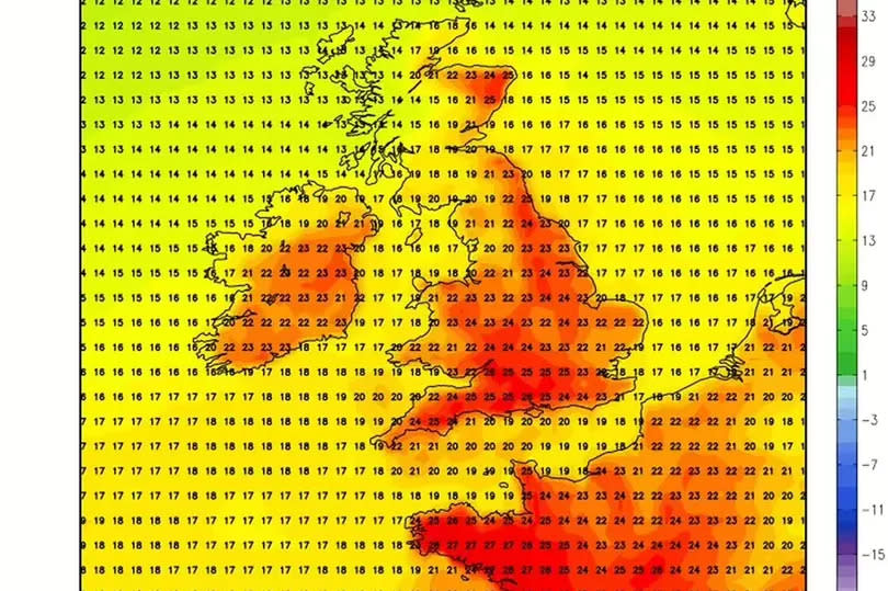
Weather maps for July 6 show that most parts of the country would heat up above 20C, with even the Scottish Highland hitting 22C, Express reports. But it could get even warmer than that.
Jim Dale, a meteorologist with British Weather Services, said: "At the moment, we are in the exchange of transition between relatively cold weather of June into a warmer, hotter stroke. What we will see is sun reactivity, a mix of situations, either the temperature will go back to average or beyond average.
"The weather is mixed for sure with some showers, thunderstorms, and above-average heat. But if Europe continues to stay hot then there is every chance that temperature could touch 30C.
"There is a certain amount of doubt so we need to watch the situation as it develops through the latter part of June. At some point between now and July 6, we could see some 30C, especially in the south, but not higher than for now."
In its long-range forecast for July 4 and 19, the Met Office said: "Signals for this period are fairly weak and thus, it's difficult to say if any one type of weather pattern will dominate. As such, typical conditions for the UK are most probable with a mixture of weather types.
"All areas can expected to see some spells of drier, sunnier weather, but there will also be showers or longer spells of rain at times. Currently the only signals, weak as they are, hint that rain and showers will tend to be more biased towards the north and west, with any more prolonged drier interludes favouring the south.
"Temperatures are slightly more likely than normal to be above average, than below."

